Tay River Subwatershed Report 2017
RUDSDALE CREEK CATCHMENT
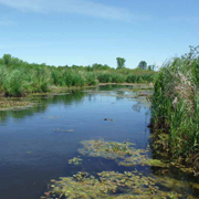
 Figure 1 Land cover in the Rudsdale Creek catchment
The RVCA produces individual reports for 14 catchments in the Tay River subwatershed. Using data collected and analyzed by the RVCA through its watershed monitoring and land cover classification programs, surface water quality and in-stream conditions are reported for the Tay River, Tay Watershed lakes and Tay tributaries along with a summary of environmental conditions for the surrounding countryside every six years, which includes analysis of data collected through the programs along with local information provided by stakeholders up to 2017.
This information is used to better understand the effects of human activity on our water resources, allows us to better track environmental change over time and helps focus watershed management actions where they are needed the most to help sustain the ecosystem services (cultural, aesthetic and recreational values; provisioning of food, fuel and clean water; regulation of erosion/natural hazard protection and water purification; supporting nutrient/water cycling and habitat provision) provided by the catchment’s lands and forests and waters (Millennium Ecosystem Assessment 2005).
The following sections of this report are a compilation of that work for the Rudsdale Creek catchment.
| Catchment Facts | Section 1.0 |
| Water Quality Conditions | Section 2.0 |
| Riparian Conditions | Section 3.0 |
| Land Cover | Section 4.0 |
| Stewardship and Water Resources Protection | Section 5.0 |
| Accomplishments | Section 6.0 |
| Challenges/Issues | Section 7.0 |
| Actions/Opportunities | Section 8.0 |
For other Tay River catchments and the Tay River Subwatershed Report, please see Rideau Valley Conservation Authority Subwatershed Reports.