5. Stewardship and Protection
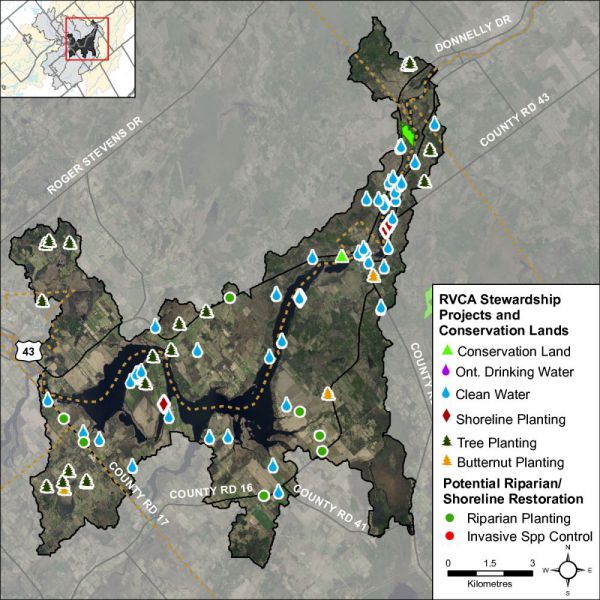
The RVCA and its partners are working to protect and enhance environmental conditions in the Middle Rideau Subwatershed. Figure 27 shows the location of all stewardship projects completed in the Rideau-Merrickville catchment along with sites identified for potential shoreline restoration.
Rural Clean Water Projects
From 2009 to 2014, seven septic system replacements, four erosion control projects, three well decommissionings, three well upgrades, one well replacement, one livestock fencing project, one milkhouse washwater treatment facility and one windbreak buffer were completed. Between 2003 and 2008, seven septic system replacements, five well decommissionings, three livestock fencing projects, two well upgrades, one windbreak buffer, one erosion control project, one fuel storage and handling facility, one nutrient management plan and one wastewater runoff project were carried out. Prior to 2003, three livestock fencing projects, two septic system replacements, one milkhouse washwater treatment facility and one manure storage facility were completed. Total value of all 50 projects is $380,843 with $207,425 of that amount funded through grant dollars from the RVCA.
Figure 27 Stewardship and potential restoration locations
Tree Planting Projects
The location of RVCA Tree Planting Program projects is shown in Figure 27. From 2009 to 2014, 18,000 trees were planted at two sites. Between 2003 and 2008, 20,476 trees were planted at six sites and prior to 2003, 28,355 trees were planted at 10 sites, resulting in the reforestation of 35 hectares. Total value of all 18 projects is $186,978 with $58,904 of that amount coming from various fundraising sources.
Through the RVCA Butternut Recovery Program, an additional 60 butternut trees were planted in the Rideau-Merrickville catchment between 2003 and 2014, as part of efforts to introduce healthy seedlings from tolerant butternuts into various locations across Eastern Ontario.
Shoreline Naturalization Projects
With the assistance of the RVCA’s Shoreline Naturalization Program, 963 trees and shrubs were planted at six project locations to create a 722 metre long shoreline buffer at a total project value of $4,183.
Valley, Stream, Wetland and Hazard Land Regulation
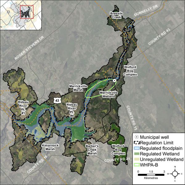
The Rideau-Merrickville catchment covers 116 square kilometres with 31.3 square kilometres (or 27 percent) of the drainage area being within the regulation limit of Ontario Regulation 174/06 (Figure 28), giving protection to wetland areas and river or stream valleys that are affected by flooding and erosion hazards.
Wetlands occupy 22.2 sq. km. (or 19 percent) of the catchment. Of these wetlands, 12.4 sq. km (or 56 percent) are designated as provincially significant and included within the RVCA regulation limit. This leaves the remaining 9.9 sq. km (or 44 percent) of wetlands in the catchment outside the regulated area limit.
Of the 176.1 kilometres of stream in the catchment, regulation limit mapping has been plotted along 86.3 kilometers of streams (representing 49 percent of all streams in the catchment). Some of these regulated watercourses (31.1 km or 18 percent of all streams) flow through regulated wetlands; the remaining 55.2 km (or 64 percent) of regulated streams are located outside of those wetlands. Plotting of the regulation limit on the remaining 89.7 km (or 51 percent) of streams requires identification of flood and erosion hazards and valley systems.
Within the regulation limit, “development” and “site alteration” require RVCA permission. The “alteration to waterways” provision of Ontario Regulation 174/06 applies to all watercourses.
Figure 28 RVCA regulation limits and Merrickville Wellhead Protection Area
Vulnerable Drinking Water Areas
The Wellhead Protection Area around the Village of Merrickville municipal drinking water source is located within the Rideau-Merrickville drainage catchment (Figure 28). This area is subject to mandatory policies in the Mississippi-Rideau Source Protection Plan developed under the Clean Water Act. These policies specifically regulate land uses and activities that are considered drinking water threats, thereby reducing the risk of contamination of the municipal drinking water source.
With the exception of the area around Kilmarnock, the Rideau-Merrickville drainage catchment is also considered to have a Highly Vulnerable Aquifer. This means that the nature of the overburden (thin soils, fractured bedrock) does not provide a high level of protection for the underlying groundwater making the aquifer more vulnerable to contaminants released on the surface. The Mississippi-Rideau Source Protection Plan includes policies that focus on the protection of groundwater region-wide due to the fact that most of the region, which encompasses the Mississippi and Rideau watersheds, is considered Highly Vulnerable Aquifer.
The lands adjacent to the Rideau River are also considered a Significant Groundwater Recharge Area. This means that there is a volume of water moving from the surface into the ground and groundwater serves either as a municipal drinking water source or supplies a lake or stream ecosystem. The Plan was not required to include policies to specifically address Significant Groundwater Recharge Areas.
For detailed maps and policies that have been developed to protect drinking water sources, please go to the Mississippi-Rideau Source Protection Region website at www.mrsourcewater.ca to view the Mississippi-Rideau Source Protection Plan.
4. Land Cover
Land cover and any change in coverage that has occurred over a six year period is summarized for the Rideau-Merrickville catchment using spatially continuous vector data representing the catchment during the spring of 2008 and 2014. This dataset was developed by the RVCA through heads-up digitization of 20cm DRAPE ortho-imagery at a 1:4000 scale and details the surrounding landscape using 10 land cover classes.
As shown in Table 11, the dominant land cover types in 2008 and 2014 were crop and pastureland and wetland, followed by settlement areas and woodland.
Table 11 Land cover (2008 vs. 2014) in the Rideau-Merrickville catchment
* Does not include treed swamps ** Includes treed swamps
From 2008 to 2014, there was an overall change of 109 hectares (from one land cover class to another). Change within the Rideau-Merrickville catchment is primarily associated with the transitioning of crop and pastureland to woodland and conversion to settlement along with the conversion of woodland to settlement and crop and pastureland (see Figure 24 for the location of the major changes).
Figure 24 Dominant land cover change in the Rideau-Merrickville catchment (2014)
Table 12 shows the type of land cover change that has taken place between land cover classes/types from 2008 to 2014. Overall, the net area of crop and pastureland change (loss) is small at 31 hectares relative to the remaining area of crop and pastureland in the catchment (as of 2014), as is the change (loss) in the area of woodland (at 19 hectares) when compared to the remaining woodland (in 2014). However, the net area of settlement change (gain) is greater (at 47 hectares) relative to the remaining area of settlement in the catchment (as of 2014).
Table 12 Land cover change in the Rideau-Merrickville catchment (2008 to 2014)
Woodland Cover
In the Environment Canada Guideline (Third Edition) entitled “How Much Habitat Is Enough?” (hereafter referred to as the “Guideline”) the opening narrative under the Forest Habitat Guidelines section states that prior to European settlement, forest was the predominant habitat in the Mixedwood Plains ecozone. The remnants of this once vast forest now exist in a fragmented state in many areas (including the Rideau Valley watershed) with woodland patches of various sizes distributed across the settled landscape along with higher levels of forest cover associated with features such as the Frontenac Axis (within the on-Shield areas of the Rideau Lakes and Tay River subwatersheds). The forest legacy, in terms of the many types of wildlife species found, overall species richness, ecological functions provided and ecosystem complexity is still evident in the patches and regional forest matrices (found in the Middle Rideau subwatershed and elsewhere in the Rideau Valley watershed). These ecological features are in addition to other influences which forests have on water quality and stream hydrology including reducing soil erosion, producing oxygen, storing carbon along with many other ecological services that are essential not only for wildlife but for human well-being.
The Guideline also notes that forests provide a great many habitat niches that are in turn occupied by a great diversity of plant and animal species. They provide food, water and shelter for these species - whether they are breeding and resident locally or using forest cover to help them move across the landscape. This diversity of species includes many that are considered to be species at risk. Furthermore, from a wildlife perspective, there is increasing evidence that the total forest cover in a given area is a major predictor of the persistence and size of bird populations, and it is possible or perhaps likely that this pattern extends to other flora and fauna groups. The overall effect of a decrease in forest cover on birds in fragmented landscapes is that certain species disappear and many of the remaining ones become rare, or fail to reproduce, while species adapted to more open and successional habitats, as well as those that are more tolerant to human-induced disturbances in general, are able to persist and in some cases thrive. Species with specialized-habitat requirements are most likely to be adversely affected. The overall pattern of distribution of forest cover, the shape, area and juxtaposition of remaining forest patches and the quality of forest cover also play major roles in determining how valuable forests will be to wildlife and people alike.
The current science generally supports minimum forest habitat requirements between 30 and 50 percent, with some limited evidence that the upper limit may be even higher, depending on the organism/species phenomenon under investigation or land-use/resource management planning regime being considered/used.
As shown in Figure 25, 31 percent of the Rideau-Merrickville catchment contains 3302 hectares of upland forest and 296 hectares of lowland forest (treed swamps) versus the 34 percent of woodland cover in the Middle Rideau subwatershed. This is greater than the 30 percent of forest cover that is identified as the minimum threshold required to sustain forest birds according to the Guideline and which may only support less than one half of potential species richness and marginally healthy aquatic systems. When forest cover drops below 30 percent, forest birds tend to disappear as breeders across the landscape.
Figure 25 Woodland cover and forest interior (2014)
Woodland (Patch) Size
According to the Ministry of Natural Resources’ Natural Heritage Reference Manual (Second Edition), larger woodlands are more likely to contain a greater diversity of plant and animal species and communities than smaller woodlands and have a greater relative importance for mobile animal species such as forest birds.
Bigger forests often provide a different type of habitat. Many forest birds breed far more successfully in larger forests than they do in smaller woodlots and some rely heavily on forest interior conditions. Populations are often healthier in regions with more forest cover and where forest fragments are grouped closely together or connected by corridors of natural habitat. Small forests support small numbers of wildlife. Some species are “area-sensitive” and tend not to inhabit small woodlands, regardless of forest interior conditions. Fragmented habitat also isolates local populations, especially small mammals, amphibians and reptiles with limited mobility. This reduces the healthy mixing of genetic traits that helps populations survive over the long run (Conserving the Forest Interior. Ontario Extension Notes, 2000).
The Environment Canada Guideline also notes that for forest plants that do not disperse broadly or quickly, preservation of some relatively undisturbed large forest patches is needed to sustain them because of their restricted dispersal abilities and specialized habitat requirements and to ensure continued seed or propagation sources for restored or regenerating areas nearby.
The Natural Heritage Reference Manual continues by stating that a larger size also allows woodlands to support more resilient nutrient cycles and food webs and to be big enough to permit different and important successional stages to co-exist. Small, isolated woodlands are more susceptible to the effects of blowdown, drought, disease, insect infestations, and invasions by predators and non-indigenous plants. It is also known that the viability of woodland wildlife depends not only on the characteristics of the woodland in which they reside, but also on the characteristics of the surrounding landscape where the woodland is situated. Additionally, the percentage of forest cover in the surrounding landscape, the presence of ecological barriers such as roads, the ability of various species to cross the matrix surrounding the woodland and the proximity of adjacent habitats interact with woodland size in influencing the species assemblage within a woodland.
In the Rideau-Merrickville catchment (in 2014), 117 (36 percent) of the 321 woodland patches are very small, being less than one hectare in size. Another 165 (51 percent) of the woodland patches ranging from one to less than 20 hectares in size tend to be dominated by edge-tolerant bird species. The remaining 39 (13 percent of) woodland patches range between 21 and 290 hectares in size. Thirty-two of these patches contain woodland between 20 and 100 hectares and may support a few area-sensitive species and some edge intolerant species, but will be dominated by edge tolerant species.
Conversely, seven (three percent) of the 321 woodland patches in the drainage area exceed the 100 plus hectare size needed to support most forest dependent, area sensitive birds and are large enough to support approximately 60 percent of edge-intolerant species. One patch tops 200 hectares, which according to the Environment Canada Guideline will support 80 percent of edge-intolerant forest bird species (including most area sensitive species) that prefer interior forest habitat conditions.
Table 13 presents a comparison of woodland patch size in 2008 and 2014 along with any changes that have occurred over that time. A decrease (of 20 ha) has been observed in the overall woodland patch area between the two reporting periods with most of the physical change in area occurring in the 20 to 50 and 100 to 200 hectare woodland patch size class ranges.
Table 13 Woodland patches in the Rideau-Merrickville catchment (2008 and 2014)
*Includes treed swamps
Forest Interior
The forest interior is habitat deep within woodlands. It is a sheltered, secluded environment away from the influence of forest edges and open habitats. Some people call it the “core” or the “heart” of a woodland. The presence of forest interior is a good sign of woodland health, and is directly related to the woodland’s size and shape. Large woodlands with round or square outlines have the greatest amount of forest interior. Small, narrow woodlands may have no forest interior conditions at all. Forest interior habitat is a remnant natural environment, reminiscent of the extensive, continuous forests of the past. This increasingly rare forest habitat is now a refuge for certain forest-dependent wildlife; they simply must have it to survive and thrive in a fragmented forest landscape (Conserving the Forest Interior. Ontario Extension Notes, 2000).
The Natural Heritage Reference Manual states that woodland interior habitat is usually defined as habitat more than 100 metres from the edge of the woodland and provides for relative seclusion from outside influences along with a moister, more sheltered and productive forest habitat for certain area sensitive species. Woodlands with interior habitat have centres that are more clearly buffered against the edge effects of agricultural activities or more harmful urban activities than those without.
In the Rideau-Merrickville catchment (in 2014), the 321 woodland patches contain 119 forest interior patches (Figure 25) that occupy five percent (643 ha.) of the catchment land area (which is equal to the five percent of interior forest in the Middle Rideau Subwatershed). This is below the ten percent figure referred to in the Environment Canada Guideline that is considered to be the minimum threshold for supporting edge intolerant bird species and other forest dwelling species in the landscape.
Most patches (102) have less than 10 hectares of interior forest, 62 of which have small areas of interior forest habitat less than one hectare in size. The remaining 17 patches contain interior forest ranging between 11 and 70 hectares in area.
Between 2008 and 2014, there has been a notable change in the number of woodland patches containing smaller areas of interior habitat (Table 14) with an increase of 43 woodlands containing less than one hectare of interior forest over this period and 16 woodlands with one to 10 hectares of interior habitat. This has occurred as a result of the loss of interior forest habitat in the larger woodland patches in the catchment over this period.
Table 14 Woodland Interior in the Rideau-Merrickville catchment (2008 and 2014)
Wetland Cover
Wetlands are habitats forming the interface between aquatic and terrestrial systems. They are among the most productive and biologically diverse habitats on the planet. By the 1980s, according to the Natural Heritage Reference Manual, 68 percent of the original wetlands south of the Precambrian Shield in Ontario had been lost through encroachment, land clearance, drainage and filling.
Wetlands perform a number of important ecological and hydrological functions and provide an array of social and economic benefits that society values. Maintaining wetland cover in a watershed provides many ecological, economic, hydrological and social benefits that are listed in the Reference Manual and which may include:
- contributing to the stabilization of shorelines and to the reduction of erosion damage through the mitigation of water flow and soil binding by plant roots
- mitigating surface water flow by storing water during periods of peak flow (such as spring snowmelt and heavy rainfall events) and releasing water during periods of low flow (this mitigation of water flow also contributes to a reduction of flood damage)
- contributing to an improved water quality through the trapping of sediments, the removal and/or retention of excess nutrients, the immobilization and/or degradation of contaminants and the removal of bacteria
- providing renewable harvesting of timber, fuel wood, fish, wildlife and wild rice
- contributing to a stable, long-term water supply in areas of groundwater recharge and discharge
- providing a high diversity of habitats that support a wide variety of plants and animals
- acting as “carbon sinks” making a significant contribution to carbon storage
- providing opportunities for recreation, education, research and tourism
Historically, the overall wetland coverage within the Great Lakes basin exceeded 10 percent, but there was significant variability among watersheds and jurisdictions, as stated in the Environment Canada Guideline. In the Rideau Valley Watershed, it has been estimated that pre-settlement wetland cover averaged 35 percent using information provided by Ducks Unlimited Canada (2010) versus the 21 percent of wetland cover existing in 2014 derived from DRAPE imagery analysis.
Using the same dataset, it is estimated that pre-settlement (historic) wetland cover averaged 32 percent in the Middle Rideau subwatershed versus the 27 percent of cover existing in 2014. This decline in wetland cover is also evident in the Rideau-Merrickville catchment (as seen in Figure 26) where there has been an eight percent decrease in the area of wetland cover from pre-settlement times to the present (as summarized in Table 15).
Figure 26 Catchment wetland cover
While there has been a reported decrease in wetland cover in the Rideau-Merrickville catchment from pre-settlement times, the remaining wetland cover in 2014 remains above the ecological thresholds cited in the Environment Canada Guideline. Nonetheless, in order to maintain critical hydrological, ecological functions along with related recreational and economic benefits provided by these wetland habitats in the catchment, a “no net loss” of currently existing wetlands should be employed to ensure the continued provision of tangible benefits accruing from them for landowners and surrounding communities.
Table 15 Wetland cover in the Middle Rideau subwatershed and Rideau-Merrickville catchment (Historic to 2014)
3. Rideau River Tributary Riparian Conditions
Shoreline Buffer Land Cover Evaluation
The riparian or shoreline zone is that special area where the land meets the water. Well-vegetated shorelines are critically important in protecting water quality and creating healthy aquatic habitats, lakes and rivers. Natural shorelines intercept sediments and contaminants that could impact water quality conditions and harm fish habitat in streams. Well established buffers protect the banks against erosion, improve habitat for fish by shading and cooling the water and provide protection for birds and other wildlife that feed and rear young near water. A recommended target (from Environment Canada’s Guideline: How Much Habitat is Enough?) is to maintain a minimum 30 metre wide vegetated buffer along at least 75 percent of the length of both sides of rivers, creeks and streams.
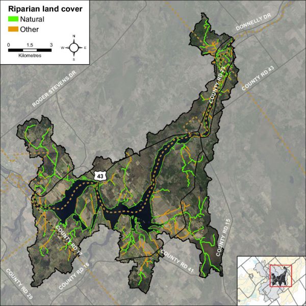
Figure 12 shows the extent of the naturally vegetated riparian zone along a 30 metre wide strip of shoreline of the Rideau River and its tributaries. This information is derived from a dataset developed by the RVCA’s Land Cover Classification Program through heads-up digitization of 20cm DRAPE ortho-imagery at a 1:4000 scale, which details the catchment landscape using 10 land cover classes.
Figure 12 Natural and other riparian land cover in the Rideau-Merrickville catchment
This analysis shows that the riparian buffer in the Rideau-Merrickville catchment is comprised of wetland (43 percent), crop and pastureland (26 percent), woodland (22 percent), settlement areas (six percent) and roads (three percent). Additional statistics for the Rideau-Merrickville catchment are presented in Table 9 and show that there has been very little change in shoreline cover from 2008 to 2014.
Table 9 Riparian land cover (2008 vs. 2014) in the Rideau-Merrickville catchment
Rideau River Tributary Instream Aquatic Habitat
Groundwater
Groundwater discharge areas can influence stream temperature, contribute nutrients, and provide important stream habitat for fish and other biota. During stream surveys, indicators of groundwater discharge are noted when observed. Indicators include: springs/seeps, watercress, iron staining, significant temperature change and rainbow mineral film. Figure 13 shows areas where one or more of the above groundwater indicators were observed during the headwater drainage feature assessments.
Figure 13 Groundwater indicators observed in the Rideau-Merrickville catchment
Headwaters Drainage Features Assessment
The RVCA Stream Characterization program assessed Headwater Drainage Features for the Middle Rosedale subwatershed in 2014. This protocol measures zero, first and second order headwater drainage features (HDF). It is a rapid assessment method characterizing the amount of water, sediment transport, and storage capacity within headwater drainage features (HDF). RVCA is working with other Conservation Authorities and the Ministry of Natural Resources and Forestry to implement the protocol with the goal of providing standard datasets to support science development and monitoring of headwater drainage features. An HDF is a depression in the land that conveys surface flow. Additionally, this module provides a means of characterizing the connectivity, form and unique features associated with each HDF (OSAP Protocol, 2013). In 2014 the program sampled 23 sites at road crossings in the Rideau – Merrickville catchment area (Figure 14).

Figure 14 Locations of the headwater sampling sites in the Rideau-Merrickville catchment
Spring photo of a headwater sample site in the Rideau-Merrickville catchment located on Putnam Road
Spring photo of a headwater sample site in the Rideau-Merrickville catchment located on Roses Bridge Road
Feature Type
The headwater sampling protocol assesses the feature type in order to understand the function of each feature. The evaluation includes the following classifications: defined natural channel, channelized or constrained, multi-thread, no defined feature, tiled, wetland, swale, roadside ditch and pond outlet. By assessing the values associated with the headwater drainage features in the catchment area we can understand the ecosystem services that they provide to the watershed in the form of hydrology, sediment transport, and aquatic and terrestrial functions. The Rideau-Merrickville catchment headwater drainage features had a wide variety of feature types including wetland, natural channel, channelized, roadside and swale. Figure 15 shows the feature type of the primary feature at the sampling locations.
Figure 15 Headwater feature types in the Rideau-Merrickville catchment
Headwater Feature Flow
The observed flow condition within headwater drainage features can be highly variable depending on timing relative to the spring freshet, recent rainfall, soil moisture, etc. Flow conditions are assessed in the spring and in the summer to determine if features are perennial and flow year round, if they are intermittent and dry up during the summer months or if they are ephemeral systems that do not flow regularly and generally respond to specific rainstorm events or snowmelt. Flow conditions in headwater systems can change from year to year depending on local precipitation patterns. Many of the features were not assessed in the summer due to timing constraints which resulted in the feature flow types being classified as unknown. Figure 16 shows the observed flow conditions at the sampling locations in the Rideau-Merrickville catchment.
Figure 16 Headwater feature flow conditions in the Rideau-Merrickville catchment
Feature Channel Modifications
Channel modifications were assessed at each headwater drainage feature sampling location. Modifications include channelization, dredging, hardening and realignments. The majority of sampling locations for the Rideau-Merrickville catchment area were classified as having no channel modifications and four appeared to have been historically dredged. Figure 17 shows the channel modifications observed at the sampling locations in the Rideau-Merrickville catchment.
Figure 17 Headwater feature channel modifications in the Rideau-Merrickville catchment
Headwater Feature Vegetation
Headwater feature vegetation evaluates the type of vegetation that is found within the drainage feature. The type of vegetated within the channel influences the aquatic and terrestrial ecosystem values that the feature provides. For some types of headwater features the vegetation within the feature plays a very important role in flow and sediment movement and provides wildlife habitat. The following classifications are evaluated no vegetation, lawn, wetland, meadow, scrubland and forest. The features assessed in the Rideau-Merrickville catchment were dominated by wetland and meadow vegetation within the features. One feature was classified as scrubland and one was classified as having lawn within the feature. Figure 18 depicts the dominant vegetation observed at the sampled headwater sites in the Rideau-Merrickville catchment.
Figure 18 Headwater feature vegetation types in the Rideau-Merrickville catchment
Headwater Feature Riparian Vegetation
Headwater riparian vegetation evaluates the type of vegetation that is found along the adjacent lands of a headwater drainage feature. The type of vegetation within the riparian corridor influences the aquatic and terrestrial ecosystem values that the feature provides to the watershed. The sample locations in Rideau - Merrickville were dominated by natural vegetation in the form of meadow, scrubland, forest and wetland vegetation. Figure 19 depicts the type of riparian vegetation observed at the sampled headwater sites in the Rideau-Merrickville catchment.
Figure 19 Headwater feature riparian vegetation types in the Rideau-Merrickville catchment
Headwater Feature Sediment Deposition
Assessing the amount of recent sediment deposited in a channel provides an index of the degree to which the feature could be transporting sediment to downstream reaches (OSAP, 2013). Evidence of excessive sediment deposition might indicate the requirement to follow up with more detailed targeted assessments upstream of the site location to identify potential best management practices to be implemented. Conditions ranged from no deposition observed to substantial deposition recorded. Figure 20 depicts the degree of sediment deposition observed at the sampled headwater sites in the Rideau-Merrickville catchment.
Figure 20 Headwater feature sediment deposition in the Rideau-Merrickville catchment
Headwater Feature Upstream Roughness
Feature roughness will provide a measure of the amount of materials within the bankfull channel that could slow down the velocity of water flowing within the headwater feature (OSAP, 2013). Materials on the channel bottom that provide roughness include vegetation, woody debris and boulders/cobble substrates. Roughness can provide benefits in mitigating downstream erosion on the headwater drainage feature and the receiving watercourse by reducing velocities. Roughness also provides important habitat conditions to aquatic organisms. The sample locations in the Rideau-Merrickville catchment area ranged from minimal to extreme roughness conditions. Figure 21 shows the feature roughness conditions at the sampling locations in the Rideau-Merrickville catchment.
Figure 21 Headwater feature roughness in the Rideau-Merrickville catchment
Fish Community
The Rideau-Merrickville catchment is classified as a mixed community of warm and cool water recreational and baitfish fishery with 27 species observed. Table 10 lists those species observed in the catchment (Source: MNR/RVCA). Figure 22 shows the sampling locations along the Rideau River and its tributaries.
Figure 22 Rideau-Merrickville fish sampling locations
Table 10 Fish species observed in the Rideau-Merrickville catchment
Riparian Restoration
Figure 23 depicts the location of several riparian restoration opportunities as a result of observations made during the headwater drainage feature assessments.
Figure 23 Riparian restoration opportunities along tributaries of the Rideau River
")
")