3. Rideau River Tributary Riparian Conditions
Shoreline Buffer Land Cover Evaluation
The riparian or shoreline zone is that special area where the land meets the water. Well-vegetated shorelines are critically important in protecting water quality and creating healthy aquatic habitats, lakes and rivers. Natural shorelines intercept sediments and contaminants that could impact water quality conditions and harm fish habitat in streams. Well established buffers protect the banks against erosion, improve habitat for fish by shading and cooling the water and provide protection for birds and other wildlife that feed and rear young near water. A recommended target (from Environment Canada’s Guideline: How Much Habitat is Enough?) is to maintain a minimum 30 metre wide vegetated buffer along at least 75 percent of the length of both sides of rivers, creeks and streams.
Figure 12 shows the extent of the naturally vegetated riparian zone along a 30 metre wide strip of shoreline of the Rideau River and its tributaries. This information is derived from a dataset developed by the RVCA’s Land Cover Classification Program through heads-up digitization of 20cm DRAPE ortho-imagery at a 1:4000 scale, which details the catchment landscape using 10 land cover classes.
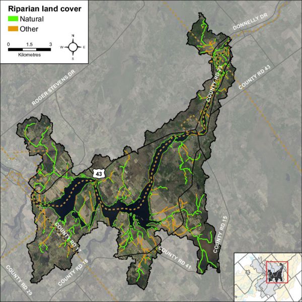
This analysis shows that the riparian buffer in the Rideau-Merrickville catchment is comprised of wetland (43 percent), crop and pastureland (26 percent), woodland (22 percent), settlement areas (six percent) and roads (three percent). Additional statistics for the Rideau-Merrickville catchment are presented in Table 9 and show that there has been very little change in shoreline cover from 2008 to 2014.
| Riparian Land Cover | 2008 | 2014 | Change - 2008 to 2014 | ||||||
|---|---|---|---|---|---|---|---|---|---|
| Area | Area | Area | |||||||
| Ha. | Percent | Ha. | Percent | Ha. | Percent | ||||
| Wetland | 427 | 43 | 432 | 43 | 5 | ||||
| > Unevaluated | (274) | (28) | (279) | (28) | (5) | (0) | |||
| > Evaluated | (153) | (15) | (153) | (15) | (0) | (0) | |||
| Crop & Pasture | 261 | 26 | 259 | 26 | -2 | ||||
| Woodland | 219 | 22 | 213 | 22 | -6 | ||||
| Settlement | 60 | 6 | 63 | 6 | 3 | ||||
| Transportation | 27 | 3 | 27 | 3 | |||||
Rideau River Tributary Instream Aquatic Habitat
Groundwater
Groundwater discharge areas can influence stream temperature, contribute nutrients, and provide important stream habitat for fish and other biota. During stream surveys, indicators of groundwater discharge are noted when observed. Indicators include: springs/seeps, watercress, iron staining, significant temperature change and rainbow mineral film. Figure 13 shows areas where one or more of the above groundwater indicators were observed during the headwater drainage feature assessments.

Headwaters Drainage Features Assessment
The RVCA Stream Characterization program assessed Headwater Drainage Features for the Middle Rosedale subwatershed in 2014. This protocol measures zero, first and second order headwater drainage features (HDF). It is a rapid assessment method characterizing the amount of water, sediment transport, and storage capacity within headwater drainage features (HDF). RVCA is working with other Conservation Authorities and the Ministry of Natural Resources and Forestry to implement the protocol with the goal of providing standard datasets to support science development and monitoring of headwater drainage features. An HDF is a depression in the land that conveys surface flow. Additionally, this module provides a means of characterizing the connectivity, form and unique features associated with each HDF (OSAP Protocol, 2013). In 2014 the program sampled 23 sites at road crossings in the Rideau – Merrickville catchment area (Figure 14).


Feature Type
The headwater sampling protocol assesses the feature type in order to understand the function of each feature. The evaluation includes the following classifications: defined natural channel, channelized or constrained, multi-thread, no defined feature, tiled, wetland, swale, roadside ditch and pond outlet. By assessing the values associated with the headwater drainage features in the catchment area we can understand the ecosystem services that they provide to the watershed in the form of hydrology, sediment transport, and aquatic and terrestrial functions. The Rideau-Merrickville catchment headwater drainage features had a wide variety of feature types including wetland, natural channel, channelized, roadside and swale. Figure 15 shows the feature type of the primary feature at the sampling locations.

Headwater Feature Flow
The observed flow condition within headwater drainage features can be highly variable depending on timing relative to the spring freshet, recent rainfall, soil moisture, etc. Flow conditions are assessed in the spring and in the summer to determine if features are perennial and flow year round, if they are intermittent and dry up during the summer months or if they are ephemeral systems that do not flow regularly and generally respond to specific rainstorm events or snowmelt. Flow conditions in headwater systems can change from year to year depending on local precipitation patterns. Many of the features were not assessed in the summer due to timing constraints which resulted in the feature flow types being classified as unknown. Figure 16 shows the observed flow conditions at the sampling locations in the Rideau-Merrickville catchment.

Feature Channel Modifications
Channel modifications were assessed at each headwater drainage feature sampling location. Modifications include channelization, dredging, hardening and realignments. The majority of sampling locations for the Rideau-Merrickville catchment area were classified as having no channel modifications and four appeared to have been historically dredged. Figure 17 shows the channel modifications observed at the sampling locations in the Rideau-Merrickville catchment.

Headwater Feature Vegetation
Headwater feature vegetation evaluates the type of vegetation that is found within the drainage feature. The type of vegetated within the channel influences the aquatic and terrestrial ecosystem values that the feature provides. For some types of headwater features the vegetation within the feature plays a very important role in flow and sediment movement and provides wildlife habitat. The following classifications are evaluated no vegetation, lawn, wetland, meadow, scrubland and forest. The features assessed in the Rideau-Merrickville catchment were dominated by wetland and meadow vegetation within the features. One feature was classified as scrubland and one was classified as having lawn within the feature. Figure 18 depicts the dominant vegetation observed at the sampled headwater sites in the Rideau-Merrickville catchment.

Headwater Feature Riparian Vegetation
Headwater riparian vegetation evaluates the type of vegetation that is found along the adjacent lands of a headwater drainage feature. The type of vegetation within the riparian corridor influences the aquatic and terrestrial ecosystem values that the feature provides to the watershed. The sample locations in Rideau - Merrickville were dominated by natural vegetation in the form of meadow, scrubland, forest and wetland vegetation. Figure 19 depicts the type of riparian vegetation observed at the sampled headwater sites in the Rideau-Merrickville catchment.

Headwater Feature Sediment Deposition
Assessing the amount of recent sediment deposited in a channel provides an index of the degree to which the feature could be transporting sediment to downstream reaches (OSAP, 2013). Evidence of excessive sediment deposition might indicate the requirement to follow up with more detailed targeted assessments upstream of the site location to identify potential best management practices to be implemented. Conditions ranged from no deposition observed to substantial deposition recorded. Figure 20 depicts the degree of sediment deposition observed at the sampled headwater sites in the Rideau-Merrickville catchment.

Headwater Feature Upstream Roughness
Feature roughness will provide a measure of the amount of materials within the bankfull channel that could slow down the velocity of water flowing within the headwater feature (OSAP, 2013). Materials on the channel bottom that provide roughness include vegetation, woody debris and boulders/cobble substrates. Roughness can provide benefits in mitigating downstream erosion on the headwater drainage feature and the receiving watercourse by reducing velocities. Roughness also provides important habitat conditions to aquatic organisms. The sample locations in the Rideau-Merrickville catchment area ranged from minimal to extreme roughness conditions. Figure 21 shows the feature roughness conditions at the sampling locations in the Rideau-Merrickville catchment.

Fish Community
The Rideau-Merrickville catchment is classified as a mixed community of warm and cool water recreational and baitfish fishery with 27 species observed. Table 10 lists those species observed in the catchment (Source: MNR/RVCA). Figure 22 shows the sampling locations along the Rideau River and its tributaries.

| Fish Species | Fish code | Fish Species | Fish code | ||||||
|---|---|---|---|---|---|---|---|---|---|
| alewife | Alewi | logperch | Logpe | ||||||
| banded killifish | BaKil | northern pike | NoPik | ||||||
| black crappie | BlCra | pumpkinseed | Pumpk | ||||||
| bluegill | Blueg | rock bass | RoBas | ||||||
| bluntnose minnow | BnMin | shorthead redhorse | ShRed | ||||||
| brook silverside | BrSil | silver redhorse | SiRed | ||||||
| brook stickleback | BrSti | smallmouth bass | SmBas | ||||||
| brown bullhead | BrBul | spotfin shiner | SpShi | ||||||
| central mudminnow | CeMud | stonecat | Stone | ||||||
| common carp | CoCar | walleye | Walle | ||||||
| emerald shiner | EmShi | white sucker | WhSuc | ||||||
| etheostoma sp. | EthSp | yellow bullhead | YeBul | ||||||
| golden shiner | GoShi | yellow perch | YePer | ||||||
| largemouth bass | LmBas |
Riparian Restoration
Figure 23 depicts the location of several riparian restoration opportunities as a result of observations made during the headwater drainage feature assessments.
