2.0 Jock River-Ashton Dwyer Hill Catchment: Surface Water Quality Conditions
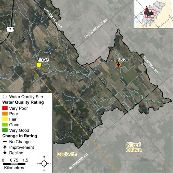
Surface water quality conditions in the Ashton-Dwyer Hill catchment of the Jock River are monitored by the City of Ottawa’s Baseline Water Quality Monitoring Program. This program provides information on the condition of Ottawa’s surface water resources; data is collected for multiple parameters including nutrients (total phosphorus, total Kjeldahl nitrogen and ammonia), E. coli, metals (like aluminum and copper) and additional chemical/physical parameters (such as alkalinity, chlorides, pH and total suspended solids). The locations of monitoring sites are shown in Figure 2 and Table 1.
2.1 Jock River Water Quality Rating
The RVCA's water quality rating for Jock River site JR-20 is “Poor” while upstream site JR-45 is “Fair” (Table 1) as determined by the Canadian Council of Ministers of the Environment (CCME) Water Quality Index[1]. A “Fair” rating indicates that water quality is usually protected but is occasionally threatened or impaired; conditions sometimes depart from natural or desirable levels. A rating of “Poor” indicates water quality is frequently threatened or impaired; conditions often depart from natural or desirable levels. Each parameter is evaluated against established guidelines to determine water quality conditions. Those parameters that frequently exceed guidelines are presented below. Table 1 shows the overall rating for the monitored surface water quality site within the Ashton-Dwyer Hill catchment and Table 2 outlines the Water Quality Index (WQI) scores and their corresponding ratings.
Analysis of the data has been broken into two periods, 2004-2009 and 2010-2015, to examine if conditions have changed within this timeframe. Water quality scores at site JR-20 declined from a rating of “Fair” in the 2004-2009 period to “Poor” in 2010-2015, this can be attributed to more exceedances across a greater number of parameters. Data is only available at site JR-45 for the 2010-2015 period. The scores at both sites are largely influenced by frequent high nutrient concentrations and periods of bacterial pollution. For more information on the CCME WQI, please see the Jock River Subwatershed Report.
| Sampling Site | Location | 2004-2009 | Rating |
|---|---|---|---|
| JR-20 | Jock River upstream of Bleeks Rd bridge at 8039 Bleeks Rd | 73 | Fair |
| JR-45 | Jock River tributary upstream of McCaffery Trail Bridge | NA | NA |
| Sampling Site | Location | 2010-2015 | Rating |
| JR-20 | Jock River upstream of Bleeks Rd bridge at 8039 Bleeks Rd | 59 | Poor |
| JR-45 | Jock River tributary upstream of McCaffery Trail Bridge | 77 | Fair |
| Rating | Index Score |
|---|---|
| Very Good (Excellent) | 95-100 |
| Good | 80-94 |
| Fair | 65-79 |
| Poor (Marginal) | 45-64 |
| Very Poor (Poor) | 0-44 |
2.2 Nutrients
Total phosphorus (TP) is used as a primary indicator of excessive nutrient loading and may contribute to abundant aquatic vegetation growth and depleted dissolved oxygen levels. The Provincial Water Quality Objective (PWQO) is used as the TP Guideline and states that in streams concentrations greater than 0.030 mg/l indicate an excessive amount of TP.
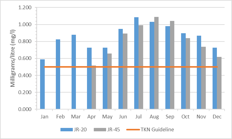
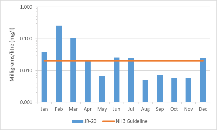
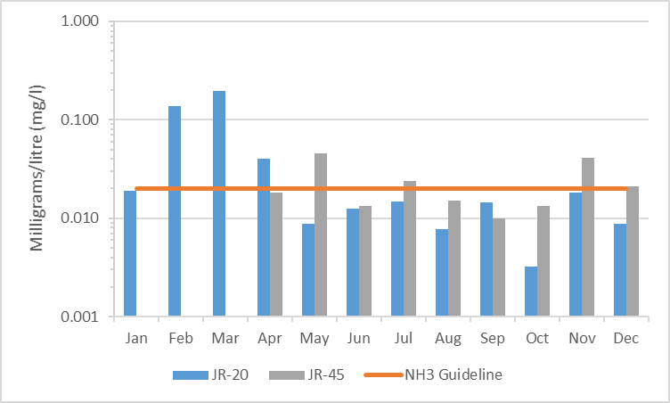
Total Kjeldahl nitrogen (TKN) and ammonia (NH3) are used as secondary indicators of nutrient loading. RVCA uses a guideline of 0.500 mg/l to assess TKN[2] and the PWQO of 0.020 mg/l to assess NH3 concentrations in the Jock River.
Tables 3, 4 and 5 summarize average nutrient concentrations at the monitored site within the Ashton-Dwyer Hill catchment and show the proportion of results that meet the guidelines.
| Total Phosphorous 2004-2009 | |||
|---|---|---|---|
| Site | Average (mg/l) | Below Guideline | No. Samples |
| JR-20 | 0.037 | 47% | 64 |
| JR-45 | NA | NA | NA |
| Total Phosphorous 2010-2015 | |||
| Site | Average (mg/l) | Below Guideline | No. Samples |
| JR-20 | 0.031 | 56% | 57 |
| JR-45 | 0.023 | 76% | 46 |
| Total Kjeldahl Nitrogen 2004-2009 | |||
|---|---|---|---|
| Site | Average (mg/l) | Below Guideline | No. Samples |
| JR-20 | 0.867 | 8% | 64 |
| JR-45 | NA | NA | NA |
| Total Kjeldahl Nitrogen 2010-2015 | |||
| Site | Average (mg/l) | Below Guideline | No. Samples |
| JR-20 | 0.874 | 0% | 57 |
| JR-45 | 0.808 | 7% | 46 |
| Ammonia 2004-2009 | |||
|---|---|---|---|
| Site | Average (mg/l) | Below Guideline | No. Samples |
| JR-20 | 0.030 | 75% | 63 |
| JR-45 | NA | NA | NA |
| Ammonia 2010-2015 | |||
| Site | Average (mg/l) | Below Guideline | No. Samples |
| JR-20 | 0.028 | 70% | 57 |
| JR-45 | 0.023 | 72% | 46 |
Monitoring Site JR-20
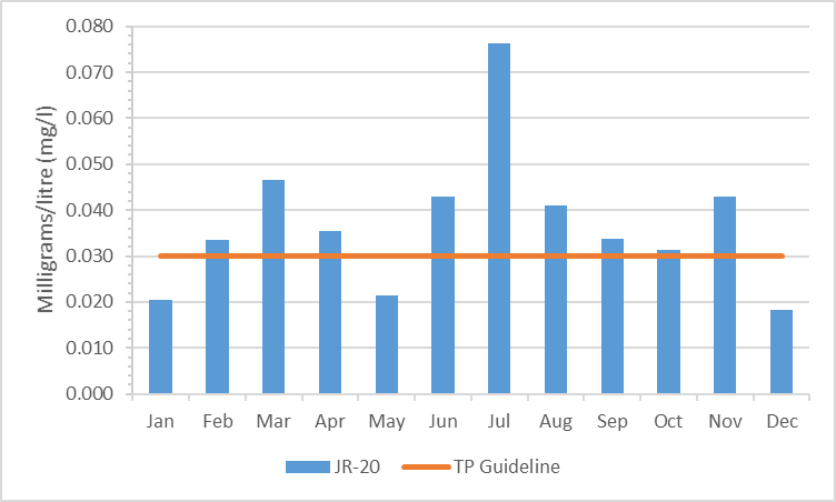
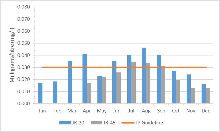
In the 2004-2009 period the majority of samples at site JR-20 were above the TP guideline; the frequency of exceedances decreased marginally in the 2010-2015 monitoring period. The number of samples below the guideline improved from 47 percent in 2004-2009 to 56 percent in 2010-2015 (Figures 3 and 4). The average TP concentrations decreased slightly from 0.037 mg/l (2004–2009) to 0.031 mg/l (2010–2015) as shown in Table 3.
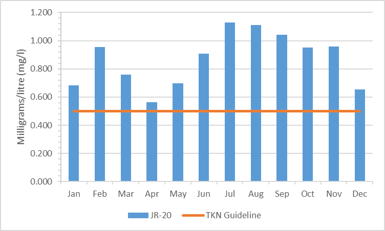
TKN concentrations show that the bulk of results exceeded the guideline (Figures 5 and 6); there were few samples (eight percent) below the guideline in the 2004-2009 period and this declined to zero samples below the guideline in the 2010-2015 period. The average concentration was generally elevated and increased from 0.867 mg/l to 0.874 mg/l (Table 4).
In the 2004-2009 reporting period 75 percent of NH3 results were below the guideline with an average concentration of 0.030 mg/l (Figure 7, Table 5). The percentage of results below the guideline declined to 70 percent in the 2010-2015 period. However, during this timeframe the average concentration also decreased marginally to 0.028 mg/l (Figure 8, Table 5).
Monitoring Site JR-45
Elevated TP results were not a common occurrence at site JR-45. Most samples, 76 percent, were below the PWQO (Figure 4). The average TP concentration was 0.023 mg/l (Table 3) and was also below the guideline (PWQO).
The bulk of TKN results have exceeded the guideline (Figure 6), with seven percent of samples below the guideline in the 2010-2015. The average concentration was elevated at 0.808 mg/l (Table 4).
The results for NH3 indicate that exceedances not common though the average concentration was above the guideline at 0.023 mg/l (Table 5). Seventy-two percent of results were below the guideline in the 2010-2015 reporting period (Figure 8).
Summary
Nutrient enrichment is a feature in this reach of the Jock River. This is likely due to natural inputs from wetland areas and runoff from surrounding agricultural lands. The Jock River was previously identified as having a marginal rating (i.e. exceeded targets occasionally) for phosphorus (City of Ottawa, Water Environment Protection Program, 2006). Overall, average nutrient concentrations have remained consistent through the monitoring periods at site JR-20. All parameters (total phosphorus, total Kjeldahl nitrogen and ammonia) have exceeded guidelines. Elevated nutrients may result in nutrient loading downstream. High nutrient concentrations can help stimulate the growth of algae blooms and other aquatic vegetation in a waterbody and deplete oxygen levels as the vegetation dies off. Consideration should also be given to the potential influence of inflow from the Jenkinson Drain into this reach of the Jock River. Best management practices such as enhanced shoreline buffers, erosion mitigation where applicable, preventing the use of fertilizers and restricting livestock access in agricultural areas can help to reduce nutrient enrichment in Jock River.
2.3 Escherichia coli
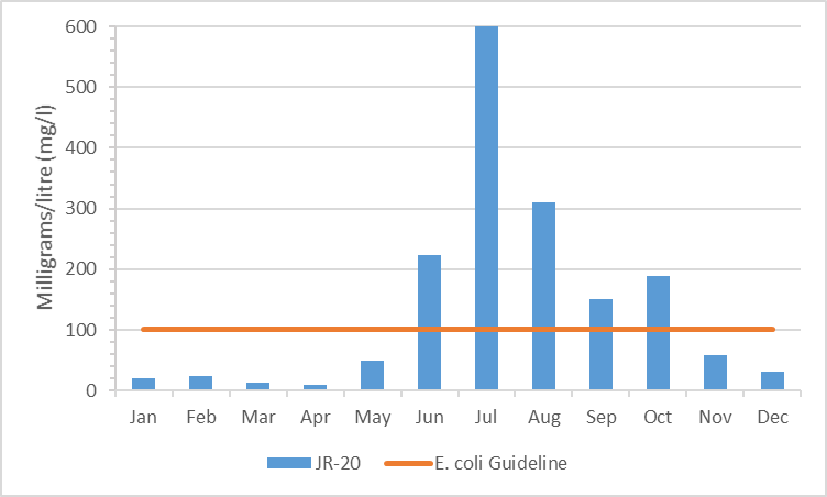
Escherichia coli (E. coli) is used as an indicator of bacterial pollution from human or animal waste; in elevated concentrations, it can pose a risk to human health. The PWQO of 100 colony forming units/100 millilitres (CFU/100 ml) is used. E. coli counts greater than this guideline indicate that bacterial contamination may be a problem within a waterbody.
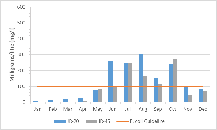
Table 6 summarizes the geometric mean[3] for the monitored sites on the Jock River within the Ashton-Dwyer Hill catchment and shows the proportion of samples that meet the E. coli guideline of 100 CFU/100 ml. The results of the geometric mean with respect to the guideline for the two periods, 2004-2009 and 2010-2015, are shown in Figures 9 and 10 respectively.
| E. coli 2004-2009 | |||
|---|---|---|---|
| Site | Geometric Mean (CFU/100ml) | Below Guideline | No. Samples |
| JR-20 | 78 | 48% | 61 |
| JR-45 | NA | NA | NA |
| E. coli 2010-2015 | |||
| Site | Geometric Mean (CFU/100ml) | Below Guideline | No. Samples |
| JR-20 | 99 | 46% | 57 |
| JR-45 | 74 | 57% | 46 |
Monitoring Site JR-20
E. coli counts at site JR-20 provide evidence of an increase in bacterial pollution. The proportion of samples below the guideline declined marginally from 48 percent (Figure 9) to 46 percent (Figure 10). The count at the geometric mean increased from 78 CFU/100ml in 2004-2009 to 99 CFU/100ml from 2010-2015 (Table 6), and is just below the PWQO.
Monitoring Site JR-45
Elevated E. coli counts at site JR-45 were also regular occurrence. Most samples were below the guideline (57 percent) in the 2010-2015 period. The geometric mean was below the PWQO of 100 CFU/100ml at 74 CFU/100ml (Table 6).
Summary
Given the results, bacterial contamination appear to be an increasing concern in this reach of the Jock River. Exceedances are common and counts at the geometric mean have increased to just below the guideline at site JR-20. As privously noted the potential impact of the Jenkinson Drain on this reach of the Jock River should also be considered. Best management practices such as enhancing shoreline buffers and restricting livestock access can help to protect this reach of the Jock River into the future.
1 The City of Ottawa Baseline Water Quality Monitoring Program has also applied the CCME WQI to monitored sites. The parameters used and time periods differs between the RVCA and City of Ottawa’s application of the WQI, resulting in different ratings at some sites.
2 No Ontario guideline for TKN is presently available; however, waters not influenced by excessive organic inputs typically range from 0.100 to 0.500 mg/l, Environment Canada (1979) Water Quality Sourcebook, A Guide to Water Quality Parameters, Inland Waters Directorate, Water Quality Branch, Ottawa, Canada
3 A type of mean or average, which indicates the central tendency or typical value of a set of numbers by using the product of their values (as opposed to the arithmetic mean which uses their sum). It is often used to summarize a variable that varies over several orders of magnitude, such as E. coli counts
