5. Stewardship and Protection
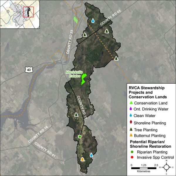
The RVCA and its partners are working to protect and enhance environmental conditions in the Middle Rideau Subwatershed. Figure 59 shows the location of all stewardship projects completed in the Dales Creek catchment along with sites identified for potential shoreline restoration.
Rural Clean Water Projects
From 2009 to 2014, two well decommissionings were completed for a total project value of $2,260 with $1,900 of that amount funded through grant dollars from the RVCA. No projects were carried out before 2009 in the catchment.
Tree Planting Projects
The location of RVCA Tree Planting Program projects is shown in Figure 59. From 2009 to 2014, 24,600 trees were planted at three sites. Prior to 2003, 4,000 trees were planted at one site, resulting in the reforestation of 14 hectares. Total value of all four projects is $99,734 with $31,143 of that amount coming from various fundraising sources. No projects were carried out in the catchment between 2003 and 2008.
Through the RVCA Butternut Recovery Program, an additional 10 butternut trees were planted in the Dales Creek catchment between 2009 and 2014, as part of efforts to introduce healthy seedlings from tolerant butternuts into various locations across Eastern Ontario.
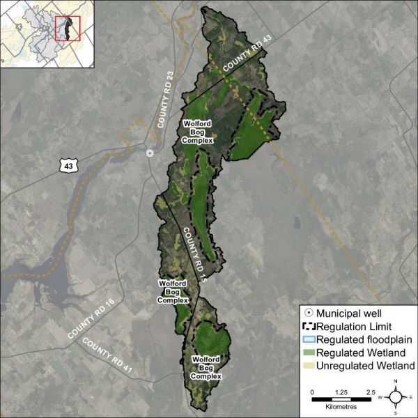
Valley, Stream, Wetland and Hazard Land Regulation
The Dales Creek catchment covers 39 square kilometres with 10.5 square kilometres (or 27 percent) of the drainage area being within the regulation limit of Ontario Regulation 174/06 (Figure 60), giving protection to wetland areas and river or stream valleys that are affected by flooding and erosion hazards.
Wetlands occupy 12.5 sq. km. (or 32 percent) of the catchment. Of these wetlands, 7.1 sq. km (or 57 percent) are designated as provincially significant and included within the RVCA regulation limit. This leaves the remaining 5.4 sq. km (or 43 percent) of wetlands in the catchment outside the regulated area limit.
Of the 46.5 kilometres of stream in the catchment, regulation limit mapping has been plotted along 17.5 kilometers of streams (representing 38 percent of all streams in the catchment). Some of these regulated watercourses (15.5 km or 33 percent of all streams) flow through regulated wetlands; the remaining 2 km (or 11 percent) of regulated streams are located outside of those wetlands. Plotting of the regulation limit on the remaining 29 km (or 62 percent) of streams requires identification of flood and erosion hazards and valley systems.
Within the regulation limit, “development” and “site alteration” require RVCA permission. The “alteration to waterways” provision of Ontario Regulation 174/06 applies to all watercourses.
Vulnerable Drinking Water Areas
The Dales Creek drainage catchment is considered to have a Highly Vulnerable Aquifer. This means that the nature of the overburden (thin soils, fractured bedrock) does not provide a high level of protection for the underlying groundwater making the aquifer more vulnerable to contaminants released on the surface. The Mississippi-Rideau Source Protection Plan includes policies that focus on the protection of groundwater region-wide due to the fact that most of the region, which encompasses the Mississippi and Rideau watersheds, is considered Highly Vulnerable Aquifer. For detailed maps and policies that have been developed to protect drinking water sources, please go to the Mississippi-Rideau Source Protection Region website at www.mrsourcewater.ca to view the Mississippi-Rideau Source Protection Plan.