1. Catchment Facts
General Geography
- The Rideau River flows through the heart of the Middle Rideau and is a focal point for residents and visitors to the area. It extends from the outlet of Lower Rideau Lake at Poonamalie (where there is one dam and one lock) to Burritts Rapids (where there is also a dam and lock), at which point it enters the Lower Rideau on its way to Rideau Falls. The Rideau River is also an integral part of the Rideau Canal National Historic Site of Canada and is a significant tourist attraction which draws boaters, cottagers, and campers to the area
- Smiths Falls, Merrickville and Burritts Rapids are the main urban settlements in the Middle Rideau subwatershed. Otter Lake is a major rural area of settlement in the catchment and Lombardy is the main urban area. Other areas of the catchment are predominantly rural in character with agriculture being a major land use
- Parks Canada staff manage water levels for recreational purposes along the Rideau Canal/Waterway that runs through the catchment, ensuring 1.5 metres of draft during the navigation season. In this managed system, water levels on the Rideau Canal are manipulated by operation of numerous dams. In the Middle Rideau subwatershed, Parks Canada staff operate 9 dam and lock complexes with 13 locks for a fall of 36.2 metres over 35.6 kilometres. Water levels are maintained as close as possible to set objectives through the May to October navigation season. The levels are lowered through the rest of October and into November and held at the winter levels until the spring freshet in late March or early April naturally increases inflows to the system. To reduce the impact of the higher flows in the spring, the amount of snow water equivalent, forecast rain, ice cover, flows and levels are assessed and the dams in the Middle Rideau reach are operated accordingly to quickly pass as much water as possible. In late April and early May, the dams are gradually closed and water levels are brought up to be ready, once again, for the navigation season
Physical Geography
- The lower three-quarters of the Otter Creek Catchment and the rest of the Middle Rideau Subwatershed primarily resides within the Smith Falls Limestone Plain, which in this area, happens to consist of older Paleozoic quartz sandstone and dolostone of the March Formation. Small sections of the bedrock in the middle and lower catchment areas are overlain by sandy glacial till. Drumlins are found in these areas. The rest of the bedrock in the catchment is overlain by a thin veneer of glacial sediment, referred to as ‘drift’ that is generally less than a metre in thickness. Geologic faults are likely located in the lower one-quarter of the catchment
- The upper one-quarter of the catchment resides within the Algonquin Highlands, which is an ancient (Precambrian) hilly area made up of thin and variable glacial deposits overlying igneous and metamorphic rock ridges and knolls. In this area, rocks consist mainly of marble and rocks associated with ancient geologic faulting
- Ninety-three percent of the catchment lies within the Township of Rideau Lakes and seven percent within the Township of Elizabethtown-Kitley
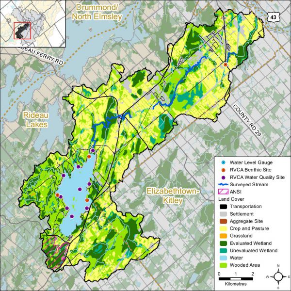
- Otter Lake and Creek catchment drainage area is 89 square kilometres and occupies about 11 percent of the Middle Rideau subwatershed and two percent of the Rideau Valley watershed
Vulnerable Areas
- The Assessment Report developed under the Ontario Clean Water Act identifies the upper bedrock aquifer underlying all of the catchment area as a Highly Vulnerable Aquifer with parts of the Nepean Sandstone found at the surface near Otter Lake also considered a Significant Groundwater Recharge Area
- Certain lands around Otter Lake are subject to flooding hazard during the regional storm flood (the 100 year flood) conditions in the area. Surveys and studies undertaken in accordance with provincial standards have determined that the 100 year flood elevation for the lake is 125.5 metres above mean sea level
Development/Trends
- There are about 330 residential properties (cottages /homes) and four commercial properties on Otter Lake with no back lot development to-date. Otter Lake has an average shoreline density of 15 properties per kilometer. Much of the waterfront property around Otter Lake was developed from the 1930’s through to the 1960’s. As the supply of subdivided lots has dwindled, the rate of new construction on new lots has slowed and been subsequently overtaken by the conversion (redevelopment) of existing cottages to large permanent residences on small lots, which continues to the present. Any new lot development is typically confined to marginal lands (with steep slopes, shallow soils, narrow waterfronts, low lying poorly-drained soils) as the remaining lands have been fully developed. This can put additional stress on the lake environment because large development envelopes on smaller lots leave less space for natural processes (e.g., runoff, infiltration and retention, nutrient uptake, erosion control and shading) and natural features (e.g., trees, shrubs and plants) that support a healthy lake environment. Minor variances are frequently triggered because the lots do not have sufficient area to provide for a minimum 30 metre development setback from the lake
- Land use in the catchment is predominately Rural (RU) and Agricultural (A) with some areas of Rural Estate Lot Subdivision (RG) located to the south of Smiths Falls. The majority of properties along the shoreline of Otter Lake are zoned Waterfront Residential (RW). Access to Otter Lake is provided via a combination of public and privately maintained roads with the majority of waterfront properties serviced by private roads. The main settlement in the catchment is the village of Lombardy, which includes both residential and commercial uses
Conditions at a Glance
Water Quality
- Surface chemistry water quality rating in Otter Lake and Otter Creek is “Fair” over two reporting periods (2003-2008; 2009-2014)
- Previous surface chemistry water quality reporting for Otter Lake presented in the 2003 Otter Lake State of the Lake Environment report noted that Otter Lake had a moderate concentration of nutrients, generally suitable fish habitat conditions and good water clarity. The data presented in the Surface Water Quality Conditions section of this 2015 report indicates that Otter Lake continues to have these conditions
- Elevated bacterial counts and nutrient concentrations from inflows of nutrients (from private septic systems, agricultural, commercial, residential surface and stormwater runoff) are a feature of Otter Creek and although surface water quality conditions have improved between the two monitoring periods, decreased nutrient and bacterial counts are needed to improve the overall health of the creek
- Instream biological water quality conditions at the Otter Creek sample location range from “Very Poor” to “Fair” from 2003 to 2014 (using a grading scheme developed by Ontario Conservation Authorities in Ontario for benthic invertebrates) with an overall benthic invertebrate water quality rating of “Poor” determined for this period
Instream and Riparian
- Overall instream and riparian condition for the Otter creek catchment as assessed by the stream characterization and headwater drainage feature assessment programs show that Otter Creek and its tributaries are in good condition. The majority of the system has low erosion levels and a healthy riparian corridor with good instream diversity of aquatic habitat. There are opportunities to improve riparian habitat along several identified headwater drainage features
- The Otter Creek catchment has 25 species of recreational and bait fish and is classified as having a warm/cool water thermal guild that supports the Otter Creek fishery
- In the Otter Lake and Creek catchment (in 2014), the riparian buffer (30 m. wide strip along the shoreline of all lakes and streams) is comprised of wetland (56 percent), woodland (24 percent), crop and pastureland (10 percent), settlement areas (seven percent) and transportation routes (three percent)
- Along Otter Creek and tributaries (in 2014), the riparian buffer is comprised of woodland (60 percent), roads (17 percent), wetland (15 percent), crop and pastureland (six percent) and settlement areas (two percent)
- Around Otter Lake (in 2014), the shoreline is dominated by cottages, houses and recreational camps (50 percent) with the remainder composed of woodland (23 percent), wetland (22 percent) and roads (five percent)
- 1994 summer survey of 100 properties on Otter Lake completed by the Township of South Elmsley determined that approximately 42 percent of its shoreline was “natural” and approximately 45 percent was “manicured lawn”. It was further estimated that the lake had 34 percent of all lots in an “untouched” state (Otter Lake Sustainable Lake Report 2015)
Land Cover
- Dominant land cover is woodland (30 percent) and crop and pastureland (29 percent) followed by wetland (22 percent), water (six percent), settlement areas (nine percent) and roads (four percent). From 2008 to 2014, there was an overall change of 138 hectares (from one land cover class to another), most of which can be attributed to the conversion of crop and pastureland and woodland to settlement along with woodland to wetland encroachment
- Woodland cover in the catchment has decreased by 64 hectares between 2008 and 2014 and interior forest habitat has decreased by 27 hectares
- Wetland cover has decreased by three percent (261 ha) from pre-settlement times to the present and now occupies 22 percent of the catchment area
Other
- Approximately 860 in-use water wells with provincial records exist in this catchment. While most water wells are used for domestic water supply, several are also used for commercial, agricultural, and public water supplies
- There are no active Permits to Take Water or Environmental Compliance Approvals in the catchment; nor are there any open or closed aggregate operations in the catchment
Catchment Care
- RVCA has monitored surface water quality in the Otter Lake and Creek catchment through its Watershed Watch Program since 2002. In 2006, the program was altered to gain consistent, year to year data for the set of lakes being monitored. RVCA monitors surface water quality in Otter Lake four times of the year at two deep point sites (eight samples annually), twice a year at three shoreline sites (six samples annually) and twice a year at an additional four sites every fifth year (eight samples in total)
- RVCA has been collecting benthic invertebrates in Otter Creek at the County Road 29 site since 2003
- RVCA conducted a fish survey along Otter Creek in 2014
- RVCA completed a stream characterization survey on Otter Creek in 2014, working upstream to the headwaters from the mouth of the creek where it empties into the Rideau River taking measurements and recording observations on instream habitat, bank stability, other attributes and preparing a temperature profile
- RVCA completed 17 headwater drainage feature assessments at road crossings in the Otter Creek catchment in 2014. This protocol measures zero and first order headwater drainage features and is a rapid assessment method characterizing the amount of water, sediment transport, and storage capacity within headwater drainage features
- RVCA provides septic system re-inspection at the request of the Township of Rideau Lakes. From 2007 to 2015, the Mississippi Rideau Septic System Office performed 66 voluntary septic system re-inspections on Otter Lake properties. Remedial/maintenance work was recommended for 62 percent of those properties that were inspected, septic system replacements at another two properties with more information provided to two other landowners with identified septic system concerns. No specific concerns were noted for the other 21 septic systems that were inspected
- Thirty-six stewardship projects have been completed with assistance from the RVCA’s Rural Clean Water and Tree Planting Programs (see Section 5 of this report for details)
- The Otter Lake Landowners’ Association is an association of property owners from all around Otter Lake that was formed in 1992. OLLA's objectives are simple and straightforward - to maintain the health of Otter Lake by working with local and regional governments, existing road associations, and individual landowners with properties on Otter Lake. The vision for the lake, as documented in the Otter Lake Sustainable Lake Plan is “A place where water quality, fish and wildlife habitat, natural beauty, recreational opportunities and peace and tranquility is maintained and improved for present and future generations to enjoy.” Values identified by property owners (in a 2015 survey) as very important include water quality (94%), swimming (70%), peace and quiet (60%), wildlife and bird watching (40%), natural shorelines (39%), sailing and paddling (39%), fishing (16%) and boating (13%). Some of the Association’s water resources management and aquatic/terrestrial habitat protection efforts include:
- Ongoing water quality monitoring of E. coli, Nitrogen and Phosphorous in conjunction with the RVCA and reporting of water quality results back to the community
- Continuing promotion of the voluntary septic system re-inspection program that the Township of Rideau Lakes introduced in 2007
- Promoting existing stewardship programs (like the RVCA’s Shoreline Naturalization Program) to the lake community to protect and enhance shorelines and protect water quality
- Continuing the water level monitoring program on Otter Lake Continue and reporting findings of the monitoring program to the community on a regular basis
- Visit Otter Lake Landowners’ Association to learn more about its activities and to view the Otter Lake Sustainable Lake Plan
- A watershed model developed by the RVCA in 2009 was used to study the hydrologic function of wetlands in the Rideau Valley Watershed, including those found in the Otter Lake and Creek catchment
- Several MOE Permits to Take Water have been issued in the vicinity of Otter Creek for golf course irrigation and water supply; for groundwater supply wells in Otterdale Estates and for a wetland conservation project requiring surface water impoundment
- Several other MOE Environmental Compliance Approvals have been issued for the disposal of effluent from large septic treatment systems at a campground, a children’s camp and a mobile home park
- The Township of Rideau Lakes has land use planning policies and zoning provisions - on lake capacity, water setbacks, frontage and naturalized shorelines and wetland protection - and use site plan control to implement these policies and provisions. Together with RVCA, the Township works with landowners on a case by case basis to achieve net environmental gains (particularly with respect to shoreline vegetation protection and rehabilitation) through the application of shoreline best management practices. Through the land-use planning process, the Township, RVCA and agencies request conditions of approval to ensure that development and redevelopment is appropriate for the property, impacts on neighbours are minimized (particularly on very small lots) and development setbacks for the shoreline are maximized
- Development in and adjacent to Provincially Significant Wetlands and some locally significant wetlands is subject to Ontario Regulation 174-06 (entitled “Development, Interference with Wetlands and Alterations to Shorelines and Watercourses”) that protects the hydrologic function of the wetland and also protects landowners and their property from natural hazards (flooding, fluctuating water table, unstable soils) associated with them
- The shoreline of Otter Lake is held in private ownership, so that the best opportunity for shoreline restoration/enhancement rests with private landowners. RVCA offers its Shoreline Naturalization Program to Otter Lake landowners to assist with shoreline re-vegetation