3.0 Flowing Creek Catchment: Riparian Conditions
3.1 Flowing Creek Instream Aquatic Habitat
3.1.1 Benthic Invertebrates
Freshwater benthic invertebrates are animals without backbones that live on the stream bottom and include crustaceans such as crayfish, molluscs and immature forms of aquatic insects. Benthos represent an extremely diverse group of aquatic animals and exhibit wide ranges of responses to stressors such as organic pollutants, sediments and toxicants, which allows scientists to use them as bioindicators. As part of the Ontario Benthic Biomonitoring Network (OBBN), the RVCA has been collecting benthic invertebrates at the Garvin Road site on Flowing Creek since 2004. Monitoring data is analyzed for each sample site and the results are presented using the Family Biotic Index, Family Richness and percent Ephemeroptera, Plecoptera and Trichoptera.
Hilsenhoff Family Biotic Index
The Hilsenhoff Family Biotic Index (FBI) is an indicator of organic and nutrient pollution and provides an estimate of water quality conditions for each site using established pollution tolerance values for benthic invertebrates. FBI results for Flowing Creek catchment sample location at Garvin Road are separated by reporting period 2004 to 2009 and 2010 to 2015. “Fair” to “Poor” water quality conditions were observed at the Flowing Creek sample location for the period from 2004 to 2015 (Fig.17) using a grading scheme developed by Conservation Authorities in Ontario for benthic invertebrates.

Family Richness
Family Richness measures the health of the community through its diversity and increases with increasing habitat diversity suitability and healthy water quality conditions. Family Richness is equivalent to the total number of benthic invertebrate families found within a sample. Flowing Creek site is reported to have “Fair” family richness (Fig.18).

EPT
Ephemeroptera (Mayflies), Plecoptera (Stoneflies), and Trichoptera (Caddisflies) are species considered to be very sensitive to poor water quality conditions. High abundance of these organisms is generally an indication of good water quality conditions at a sample location. The benthic invertebrate community structure is dominated by species that are tolerant to poor water quality conditions. As a result, the EPT indicates that Flowing Creek sample location is reported to have “Poor” water quality (Fig.19) from 2004 to 2015.


Conclusion
Overall Flowing Creek sample location aquatic habitat conditions from a benthic invertebrate perspective is considered “Poor” from 2004 to 2015 as the samples are dominated by species that are tolerant to high organic pollution levels.
3.1.2 Thermal Regime
Many factors can influence fluctuations in stream temperature, including springs, tributaries, precipitation runoff, discharge pipes and stream shading from riparian vegetation. Water temperature is used along with the maximum air temperature (using the Stoneman and Jones method) to classify a watercourse as either warm water, cool water or cold water. Figure 20 shows where the thermal sampling sites were located on Flowing Creek. Analysis of the data collected indicates that Flowing Creek is classified as a warm water system with cool to warm water reaches (Figure 21).


Each point on the graph represents a temperature that meets the following criteria:
- Sampling dates between July 1st and September 7th
- Sampling date is preceded by two consecutive days above 24.5 °C, with no rain
- Water temperatures are collected at 4pm
- Air temperature is recorded as the max temperature for that day
3.1.3 Groundwater
Groundwater discharge areas can influence stream temperature, contribute nutrients, and provide important stream habitat for fish and other biota. During headwater surveys, indicators of groundwater discharge are noted when observed. Indicators include: springs/seeps, watercress, iron staining, significant temperature change and rainbow mineral film. Figure 22 shows areas where one or more of the above groundwater indicators were observed during headwater drainage feature assessments.

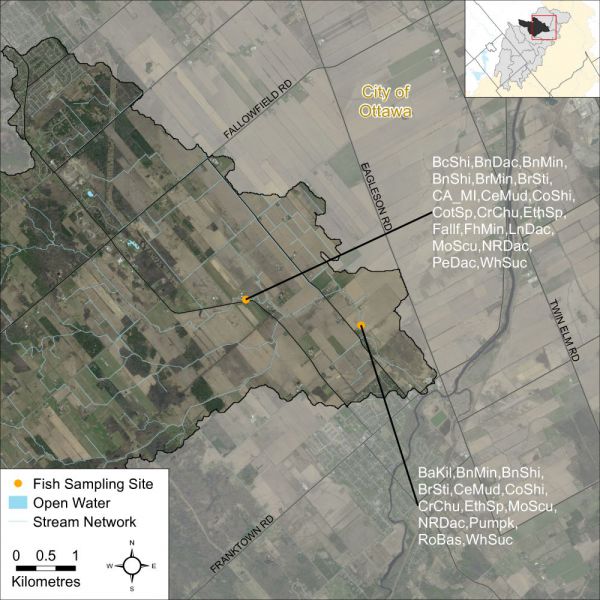
3.1.4 Fish Community
The Flowing Creek catchment is classified as a mixed community of warm and cool water recreational and baitfish fishery with 24 species observed. Figure 23 shows the RVCA sampling locations in the Flowing Creek catchment.
The following table contains a list of species observed in the watershed.
| Fish Species | Fish code | Fish Species | Fish code |
|---|---|---|---|
| banded killifish | BaKil | creek chub | CrChu |
| black crappie | BlCra | etheostoma sp. (darter) | EthSp |
| blackchin shiner | BcShi | fallfish | Fallf |
| blacknose dace | BnDac | fathead minnow | FhMin |
| blacknose shiner | BnShi | finescale dace | FsDac |
| bluntnose minnow | BnMin | longnose dace | LnDac |
| brassy minnow | BrMin | mottled sculpin | MoScu |
| brook stickleback | BrSti | northern pearl dace | PeDac |
| carps and minnows | CA_MI | northern redbelly dace | NRDac |
| central mudminnow | CeMud | pumpkinseed | Pumpk |
| common shiner | CoShi | rock bass | RoBas |
| cottus sp. (sculpin) | CotSp | white sucker | WhSuc |
3.2 Flowing Creek Headwater Drainage Features Assessment
3.2.1 Headwaters Sampling Locations
The RVCA Stream Characterization program assessed Headwater Drainage Features for the Jock River subwatershed in 2015. This protocol measures zero, first and second order headwater drainage features (HDF). It is a rapid assessment method characterizing the amount of water, sediment transport, and storage capacity within headwater drainage features (HDF). RVCA is working with other Conservation Authorities and the Ministry of Natural Resources and Forestry to implement the protocol with the goal of providing standard datasets to support science development and monitoring of headwater drainage features. An HDF is a depression in the land that conveys surface flow. Additionally, this module provides a means of characterizing the connectivity, form and unique features associated with each HDF (OSAP Protocol, 2013). In 2015 the program sampled 14 sites at road crossings in the Flowing Creek catchment area (Figure 24).

3.2.2 Headwater Feature Type
The headwater sampling protocol assesses the feature type in order to understand the function of each feature. The evaluation includes the following classifications: defined natural channel, channelized or constrained, multi-thread, no defined feature, tiled, wetland, swale, roadside ditch and pond outlet. By assessing the values associated with the headwater drainage features in the catchment area we can understand the ecosystem services that they provide to the watershed in the form of hydrology, sediment transport, and aquatic and terrestrial functions. Six features were classified as having been channelized, four features were classified as wetland, two features were road side ditches and two features were identified as natural. Figure 25 shows the feature type of the primary feature at the sampling locations.

3.2.3 Headwater Feature Flow
The observed flow condition within headwater drainage features can be highly variable depending on timing relative to the spring freshet, recent rainfall, soil moisture, etc. Flow conditions are assessed in the spring and in the summer to determine if features are perennial and flow year round, if they are intermittent and dry up during the summer months or if they are ephemeral systems that do not flow regularly and generally respond to specific rainstorm events or snowmelt. Flow conditions in headwater systems can change from year to year depending on local precipitation patterns. Figure 26 shows the observed flow conditions at the sampling locations in the Flowing Creek catchment in 2015.


3.2.4 Feature Channel Modifications
Many of the headwater drainage features within the Flowing Creek catchment area are classified as municipal drains. Channel modifications were assessed at each headwater drainage feature sampling location. Modifications include dredging, channel hardening and mixed modifications. The Flowing Creek catchment area had five features with no modifications, one feature was classified as being hardened, seven classified as dredged and one was identified as having mixed modifications. Figure 27 shows the channel modifications observed at the sampling locations for Flowing Creek.

3.2.5 Headwater Feature Vegetation
Headwater feature vegetation evaluates the type of vegetation that is found within the drainage feature. The type of vegetated within the channel influences the aquatic and terrestrial ecosystem values that the feature provides. For some types of headwater features the vegetation within the feature plays a very important role in flow and sediment movement and provides fish and wildlife habitat. The following classifications are evaluated no vegetation, lawn, wetland, meadow, scrubland and forest. The features assessed in the Flowing Creek catchment were classified as being dominated by wetland and meadow vegetation. Two features were classified as having no vegetation and one feature was dominated by recently cut grasses (lawn) within the channel. Figure 28 depicts the dominant vegetation observed at the sampled headwater sites in the Flowing Creek catchment.

3.2.6 Headwater Feature Riparian Vegetation
Headwater riparian vegetation evaluates the type of vegetation that is found along the adjacent lands of a headwater drainage feature. The type of vegetation within the riparian corridor influences the aquatic and terrestrial ecosystem values that the feature provides to the watershed. Five sample locations in Flowing Creek were dominated by natural vegetation in the form of scrubland and meadow vegetation. Nine sample locations were dominated by other forms of vegetation of either crops or ornamental grasses. Figure 29 depicts the type of riparian vegetation observed at the sampled headwater sites in the Flowing Creek catchment.

3.2.7 Headwater Feature Sediment Deposition
Assessing the amount of recent sediment deposited in a channel provides an index of the degree to which the feature could be transporting sediment to downstream reaches (OSAP, 2013). Evidence of excessive sediment deposition might indicate the requirement to follow up with more detailed targeted assessments upstream of the site location to identify potential best management practices to be implemented. Conditions ranged from no deposition observed to extensive deposition recorded. Figure 30 depicts the degree of sediment deposition observed at the sampled headwater sites in the Flowing Creek catchment.

3.2.8 Headwater Feature Upstream Roughness
Feature roughness will provide a measure of the amount of materials within the bankfull channel that could slow down the velocity of water flowing within the headwater feature (OSAP, 2013). Materials on the channel bottom that provide roughness include vegetation, woody debris and boulders/cobble substrates. Roughness can provide benefits in mitigating downstream erosion on the headwater drainage feature and the receiving watercourse by reducing velocities. Roughness also provides important habitat conditions for aquatic organisms. The sample locations in the Flowing Creek catchment area ranged from minimal to extreme roughness conditions. Figure 31 shows the feature roughness conditions at the sampling locations in the Flowing Creek catchment.
