1. Catchment Facts
General Geography
- The Rideau River flows through the heart of the Middle Rideau and is a focal point for residents and visitors to the area. It extends from the outlet of Lower Rideau Lake at Poonamalie (where there is one dam and one lock) to Burritts Rapids (where there is also a dam and lock), at which point it enters the Lower Rideau on its way to Rideau Falls. The Rideau River is also an integral part of the Rideau Canal National Historic Site of Canada and is a significant tourist attraction which draws boaters, cottagers, and campers to the area
- Smiths Falls, Merrickville and Burritts Rapids are the main settlements in the Middle Rideau subwatershed. The Barbers Creek catchment is predominantly rural in character with agriculture being the main land use
- Parks Canada staff manage water levels for recreational purposes along the Rideau Canal/Waterway that flows by the catchment, ensuring 1.5 metres of draft during the navigation season. In this managed system, water levels on the Rideau Canal are manipulated by operation of numerous dams. In the Middle Rideau subwatershed, Parks Canada staff operate 9 dam and lock complexes with 13 locks for a fall of 36.2 metres over 35.6 kilometres. Water levels are maintained as close as possible to set objectives through the May to October navigation season. The levels are lowered through the rest of October and into November and held at the winter levels until the spring freshet in late March or early April naturally increases inflows to the system. To reduce the impact of the higher flows in the spring, the amount of snow water equivalent, forecast rain, ice cover, flows and levels are assessed and the dams in the Middle Rideau reach are operated accordingly to quickly pass as much water as possible. In late April and early May, the dams are gradually closed and water levels are brought up to be ready, once again, for the navigation season
Physical Geography
- All of the Barbers Creek catchment and the rest of the Middle Rideau subwatershed primarily resides within the Smith Falls Limestone Plain, which in this area, consists mainly of older Paleozoic quartz sandstone and dolostone of the March Formation. Oxford Formation dolostone is, however, found at the northern tip of the catchment. A small area of the bedrock in the lower (northern) catchment is overlain with a rocky, sandy glacial till plain, which may host drumlins. The rest of the bedrock in the catchment is overlain by a thin veneer of glacial sediment, referred to as ‘drift’ that is generally less than a metre in thickness along with organic deposits underlying the two main wetlands in the catchment
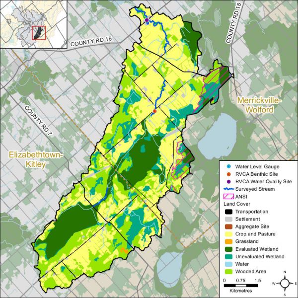
- Sixty percent of the catchment lies within the Village of Merrickville-Wolford and 40 percent within the Township of Elizabethtown-Kitley
- Barbers Creek catchment drainage area is 48 square kilometres and occupies about six percent of the Middle Rideau subwatershed and one percent of the Rideau Valley watershed
Vulnerable Areas
- Lower reach of Barbers Creek is subject to a flooding hazard during the regional storm flood (the 100 year flood). Surveys and studies undertaken in accordance with provincial standards have determined that the 100 year flood elevation in this area ranges from 108.7 metres above mean sea level at Barber Road to 103.8 metres above mean sea level at its outlet to the Rideau River
- The Assessment Report developed under the Ontario Clean Water Act identifies the upper bedrock aquifer underlying all of the catchment area as a Highly Vulnerable Aquifer, although, where sediments are thicker in a local area, the vulnerability would be less
Development
- Land uses in the catchment are Rural and Agriculture with some Wetland
Conditions at a Glance
Water Quality
- Surface chemistry water quality rating in Barbers Creek is “Fair” over two reporting periods (2003-2008 and 2009-2014). Elevated bacterial counts and nutrient concentrations from inflows of nutrients (from private septic systems, agricultural and residential surface water runoff) are a feature of Barbers Creek. Decreased nutrient and bacterial counts are needed to improve the overall health of the creek
- Instream biological water quality conditions at the Barbers Creek sample location range from “Very Poor” to “Good” from 2003 to 2014 (using a grading scheme developed by Ontario Conservation Authorities in Ontario for benthic invertebrates) with an overall benthic invertebrate water quality rating of “Poor” to “Good” determined for this period
Instream and Riparian
- Overall instream and riparian condition for the Barbers creek catchment as assessed by the stream characterization and headwater drainage feature assessment programs show that Barbers Creek and its tributaries are in generally fair condition. The majority of the system has low erosion levels and a healthy riparian corridor. Instream diversity of aquatic habitat is fairly uniform. An opportunity was identified along one of the headwater drainage features to enhance riparian habitat conditions
- The Barbers Creek catchment has 28 species of recreational and bait fish and is classified as having a warm/cool water thermal guild that supports the Barbers Creek/Rideau River fishery
- In the Barbers Creek catchment, the riparian buffer (30 m. wide strip along the shoreline of all lakes and streams) is comprised of wetland (46 percent), crop and pastureland (34 percent), woodland (17 percent), roads (two percent) and settlement areas (one percent)
Land Cover
- Dominant land cover is crop and pastureland (40 percent), followed by wetland (29 percent), woodland (26 percent), settlement areas (three percent) and roads (two percent). From 2008 to 2014, there was an overall change of 102 hectares (from one land cover class to another). While a large portion of change for Barbers Creek is a result of the conversion of woodland to crop and pastureland, it also appears that a similar proportion of change is associated with crop and pastureland emerging as young woodland
- Woodland cover in the catchment has decreased by 13 hectares between 2008 and 2014 and interior forest habitat has increased by six hectares
- Wetland cover has decreased by four percent (209 ha) from pre-settlement times to the present and now occupies 29 percent of the catchment area
Other
- Approximately 98 in-use water wells with provincial records exist in this catchment. While most water wells are used for domestic water supply, several are also used for agricultural purposes along with one other that is used as a public water supply
- There are no active Permits to Take Water or Environmental Compliance Approvals in the catchment; nor are there any open or closed aggregate operations in the catchment
Catchment Care
- Eight stewardship projects have been completed with assistance from the RVCA’s Rural Clean Water and Tree Planting Programs (see Section 5 of this report for details)
- Barbers Creek surface water quality has been monitored by the RVCA through its Baseline Monitoring Program since 2003. The surface water quality at site BAR-01 is monitored once a month from April to November
- RVCA has been collecting benthic invertebrates in Barbers Creek at the Weedmark Road site since 2003
- RVCA conducted a fish survey along Barbers Creek in 2014
- RVCA completed a stream characterization survey on Barbers Creek in 2014, working upstream to the headwaters from the mouth of the creek where it empties into the Rideau River taking measurements and recording observations on instream habitat, bank stability, other attributes and preparing a temperature profile
- RVCA completed five headwater drainage feature assessments at road crossings in the Barbers Creek catchment in 2014. This protocol measures zero and first order headwater drainage features and is a rapid assessment method characterizing the amount of water, sediment transport, and storage capacity within headwater drainage features
- A watershed model developed by the RVCA in 2009 was used to study the hydrologic function of wetlands in the Rideau Valley Watershed, including those found in the Barbers Creek catchment
- The Township of Elizabethtown-Kitley and the Village of Merrickville-Wolford have land use planning policies and zoning provisions - on water setbacks, frontage and naturalized shorelines and wetland protection - and in some instances use site plan control to implement these policies and provisions. Together with RVCA, these municipalities work with landowners on a case by case basis to enable new development while ensuring the scale is suitable on the lot, impacts on neighbours are minimized and development maximizes the watercourse setback
- Development in and adjacent to the Provincially Significant Wetlands in the catchment (Barber’s Creek Marsh, Irish Lake-Barber Creek, Wolford Bog Part 1) are subject to Ontario Regulation 174-06 (entitled “Development, Interference with Wetlands and Alterations to Shorelines and Watercourses”) that protects the hydrologic function of the wetland and also protects landowners and their property from natural hazards (flooding, fluctuating water table, unstable soils) associated with them