Open menu

Rideau - Smiths Falls

Full Catchment Report

smiths falls hardened shore

Middle Rideau Subwatershed Report 2015

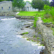
RIDEAU-SMITHS FALLS CATCHMENT


The RVCA produces individual reports for ten catchments about environmental conditions in the Middle Rideau subwatershed using data collected and analysed by the RVCA through its watershed monitoring and land cover classification programs every six years.

This information is used to better understand the effects of human activity on our water resources, allows us to better track environmental change over time and helps focus watershed management actions where they are needed the most to help sustain the ecosystem services (cultural, aesthetic and recreational values; provisioning of food, fuel and clean water; regulation of erosion/natural hazard protection and water purification; supporting nutrient/water cycling and habitat provision) provided by the catchment’s lands and forests and waters (Millennium Ecosystem Assessment 2005).

The following pages of this report are a compilation of that work and contain information on surface water quality, riparian conditions, land cover, stewardship activity and hazard land and water resources protection.

The Town of Smiths Falls has recently completed a number of Master Planning initiatives (as part of its Official Plan review process) including: the Downtown Revitalization and Waterfront Integration Master Plan (2013), the Downtown Community Improvement Plan (2013), the Smiths Falls Cultural Master Plan (2013) as well as the priorities of the 2011-2013 “Turning Point” Economic Development Action Plan, culminating in the release of the Smiths Falls 2034 Official Plan (2014).

The following list of “Challenges/Issues” and “Opportunities/Actions” contains some of those items (identified with an asterisk) taken from the Official Plan (with input from staff) and Master Planning documents that have implications for the sustainable use and management of the water resources of the Rideau River and Canal and lands adjacent to the waterfront in the Town of Smtihs Falls.

5. Challenges/Issues

Water Quality

  • Surface water quality data is unavailable for the Rideau River and Canal flowing through the Town of Smith Falls and the catchment at large

Shorelines/Headwaters

  • All riparian areas fall below the recommended 75 percent naturally vegetated riparian, 30 metre wide shoreline buffer target. In the Rideau-Smiths Falls catchment, the Rideau River and its tributaries contain 67 percent natural land cover (made up of wetland and woodland) and 33 percent non-natural land cover (comprised of crop and pastureland, rural/urban settlements and roads and railways). In the Town of Smiths Falls, the riparian buffer is made up of 53 percent non-natural land cover (comprised of commercial, industrial, institutional and residential areas, roads and railways and crop and pastureland) and 47 percent natural land cover (made up of wetland and woodland). Along the Rideau River and Canal in the Town, the shoreline buffer is made up of 71 percent non-natural land cover (commercial, institutional, residential areas and roads and railways) and 29 percent natural land cover (wetland and woodland)
  • Emerald ash borer poses a significant threat to the ecology of the catchment, given the prominence of ash trees along shorelines and in riparian and wetland areas. Many tree stands are predominantly ash and with their anticipated loss, it is unclear what will replace them and the overall effect of their collective demise on the physical and natural functions/values they provide for erosion, water quality and fish and wildlife habitat protection. Infestation is now evident in many parts of the catchment and treatment of trees is an expensive but viable option for specific specimens

Water Levels

  • Fluctuating water levels and high spring runoff turbidity in the Rideau River pose challenges to the Town of Smiths Falls municipal drinking water source. These variables are factors associated with seasonal damming and operation of the Poonamalie Dam by the Parks Canada Agency *

Development

  • Private land ownership on the north shore of the lower basin in the Town of Smiths Falls poses a challenge for a cohesive parkland loop either side of the Rideau Canal *
  • Reduced channel width of the Rideau Canal through Smiths Falls, particularly east of Parks Canada’s Combined Lock Station, limits the ability to develop marina or harbour infrastructure in close proximity to the Downtown *

Natural Hazards

  • Floodplain mapping for the Middle Rideau is over 35 years out of date for that reach of the Rideau River extending from Smiths Falls to Burritts Rapids

Land Cover/Natural Heritage System

  • Connection between natural heritage resources is an important ecological function which has yet to be analyzed or studied in Smiths Falls *
  • The catchment contains 567 ha of unevaluated wetland (occupying 12 percent of its total area) that provides many important social, hydrological, biological and ecological functions/services. Although not under imminent threat from development activity, they do remain vulnerable to drainage and land clearing activities in the absence of any regulatory and planning controls that would otherwise protect them

6. Opportunities/Actions

Water Resources

Town of Smiths Falls

  • Work with the Town to minimize the adverse effects on ground and surface water quality and quantity and protect property and natural resources from stormwater runoff generated in Smiths Falls as it proceeds with its Downtown and Waterfront Revitalization and other development projects with respect to:
    • Major development or redevelopment that will be preceded by the preparation of a watershed or subwatershed plan prepared in consultation with the Conservation Authority and Provincial ministries and the Town *
    • The servicing strategy for the north-eastern part of the Town which should take into account the need for watershed and/or sub-watershed planning *
    • Subdivision and site plan applications where no sub-watershed plan or environmental management plan exists. Under these circumstances, the Town will review stormwater site management plans in consultation with the Conservation Authority *
  • Assist the Town in protecting its water resources (aquifer/recharge areas, streams, creeks, river and riparian vegetation) that are vital to its health as a safe drinking water source, as well as the ecological and economic health of the region and its residents by:
    • Restricting or carefully regulating public and private development in shoreline areas adjacent to the Rideau River and Canal so as to protect and preserve the health, function and stability of these waterbodies *
    • Preserving water quality when establishing appropriate public access and recreational uses on land adjacent to the river and canal, creeks, wetlands and other significant water courses *
    • Restricting or carefully regulating public and private development in upland areas so as to prevent uncontrolled runoff that could impact the health and stability of these waterbodies *
  • Extend the RVCA’s Baseline Water Quality Monitoring Program to include monitoring sites through the Town of Smiths Falls to enable regular reporting of surface water quality along the Rideau River and Canal

Townships of Drummond/North Elmsley and Montague

  • Educate residents/landowners about septic system care by providing information about sewage system maintenance (i.e., when to pump out septic systems and holding talks)
  • Offer septic repair/replacement project funding provided by the Rideau Valley Rural Clean Water Program to residents/landowners
  • Promote efforts to reduce pollutant loadings to the Rideau River and Canal through application of shoreline, stormwater and agricultural best management practices; also consider using low impact development (LID) methods to improve the quality and reduce the amount of stormwater runoff reaching the Rideau River ecosystem. This may be particularly beneficial in areas with extensive impervious surfaces (i.e., asphalt, concrete, buildings, and severely compacted soils) or on sensitive waterfront properties (with steep slopes/banks, shallow/impermeable soils
  • Continue to protect the water resources of the Rideau River and Canal through implementation of municipal (Town of Smiths Falls, Townships of Drummond/North Elmsley and Montague) and agency (MOE, Parks Canada) land use planning and development policies, practices and standards​

Shorelines/Headwaters

  • Much of the shoreline of the Rideau River and Canal is held in public ownership, so that the best opportunity for shoreline restoration/enhancement rests with the Town of Smiths Falls, the Townships of Drummond/North Elmsley, Montague and Rideau Lakes and the Parks Canada Agency. RVCA offers its Shoreline Naturalization Program to municipalities, agencies, and landowners to assist with shoreline re-vegetation
  • RVCA and its partners (Town of Smiths Falls, the municipalities of Drummond/North Elmsley, Montague and Rideau Lakes and Parks Canada Agency) are to continue educating landowners about the value and importance of natural shorelines and waterfront property best management practices with respect to shoreline use, development and shoreline vegetation retention and enhancement
  • Protect the riparian buffer along the shoreline of the Rideau River and its tributaries during the development approvals process through adherence to and enforcement of municipal land-use policies and zoning standards
  • Support the Town of Smiths Falls through its economic renewal, as it goes about implementing its Economic Development Action Plan (2011), Downtown Revitalization and Waterfront Integration Master Plan (2013) and Official Plan (2014) that “supports the retention or restoration of riparian corridors” (p.23). Efforts are to be focused on the Rideau River and Canal corridor including the 1) The “Lower Town” Waterfront Redevelopment Area; 2) The Rideau Canal and Waterfront Greenway; 3) The Lower Reach Park and Old Sly’s Lock area and 4) The Upper Reach and Swale Wetland. Specific projects associated with these areas of focus along the Town’s Waterfront include:​
    • Shoreline naturalization of the Rideau River and Canal in Lower Reach Park *
    • Construction of a boardwalk and interpretative signage along the Rideau River and Canal *
    • Completion of a cohesive parkland loop along the north and south shore of the Rideau River and Canal *
    • Water based recreational infrastructure (beaches, boat launches, docks) along Lower Reach Park *
  • Target shoreline restoration at sites identified in this report (shown as “Other riparian land cover” in Figure 1 and “Potential Riparian/Shoreline Restoration” in Figure 11) and explore other restoration and enhancement opportunities along the Rideau River and its tributaries

Development

Town of Smiths Falls

  • There is potential for the redevelopment and intensification of the Town’s Water Treatment Plant and Mills Complex and along the Northshore of the upper basin. As parcels along the shoreline are quite large with several being under public ownership (Town or Parks Canada), there is a greater opportunity for a Private-Public-Partnership Project to make things happen
  • Large parcels adjacent to the Swale wetland pose potential for restoration and repair as former industrial lands. Partnerships with REAL and Parks Canada can be leveraged to assist in providing interpretive centres/panels to encourage stewardship of the natural resource
  • The potential relocation of the seasonal campground on the southern shore of the upper basin in the Town presents an opportunity for new tourism commercial and recreational uses while creating a visible gateway to the Rideau waterfront from Lombard Street

Rideau-Smiths Falls Catchment

  • Collectively work with approval authorities (Township of Drummond/North Elmsley, Township of Montague, Township of Rideau Lakes, Town of Smiths Falls, Conservation Authority, the Health Unit and Mississippi-Rideau Septic System Office) to consistently implement current land use planning and development policies for water quality and shoreline protection adjacent to the Rideau River and Canal and other catchment streams (i.e., to attain a minimum 30 metre development setback from water)
  • Explore ways and means to more effectively enforce and implement conditions of land-use planning and development approval to achieve net environmental gains (particularly with respect to rehabilitating or protecting naturally vegetated shorelines and water quality)
  • Encourage Committees of Adjustment to take advantage of technical and environmental information and recommendations forthcoming from planning and environmental professionals
  • Municipalities and agencies are encouraged to strengthen natural heritage and water resources official plan policies and zoning provisions (water setbacks, frontage and naturalized shorelines and wetland protection) where deemed appropriate
  • Utilize RVCA subwatershed and catchment reports to help develop/revise official plan policies to protect surface water resources and the natural environment (including woodlands, wetlands and shoreline cover)
  • Consider establishing RVCA regulations limits to protect additional wetlands

Land Cover/Natural Heritage System

  • Support the Town of Smiths Falls with implementation of its Environmental Vision and related policies set out in the Official Plan with an emphasis on naturally vegetated areas (including parks and trail corridors), natural features (The Swale Wetland), corridors (including utility corridors) and ecological functions, mostly associated with the Town’s woodlands, wetlands, waterways (canal/river), unevaluated wetlands and previously disturbed areas that could be re-naturalized, all of which form the basis of a Natural Heritage System for Smiths Falls and natural connections for a Natural Heritage Linkage providing both recreation and leisure opportunities as well as habitat corridors. The concept of a “Natural Heritage System” is important to the long term sustainable function of the natural heritage resources of the area. The Conservation Authority will cooperate with Smiths Falls and senior levels of government to analyze and study connections between natural heritage features and areas to help define the natural heritage system in a meaningful way (that is an integral part of the Town’s economic renewal) (S.F.O.P., p.20)

Natural Hazards

  • Continue to assist the Town of Smiths Falls with efforts to incorporate safety considerations into the Town’s planning and decision making processes to reduce those risks associated with development in hazardous areas, which can result in significant costs to individuals and the community, including major property damage as well as the potential loss of life and avoid expenses borne by the Town to repair and replace public infrastructure in hazardous areas (S.F.O.P., p.50)
  • RVCA provides ongoing “hazardous lands management” support to the Town of Smiths Falls, the Townships of Drummond/North Elmsley, Montague and Rideau Lakes through its Hazardous Lands (flood plain, unstable slope) Management Program. In this catchment, this will require that updated floodplain mapping be prepared for the reach of the Rideau River extending from Smiths Falls to Burritts Rapids


watershed checkup

The RVCA is part of the provincial Watershed Checkup Program.