Full Catchment Report
Middle Rideau Subwatershed Report 2015
BARBERS CREEK CATCHMENT
The Rideau Valley Conservation Authority produces individual reports for ten catchments in the Middle Rideau subwatershed. Using data collected and analysed by the RVCA through its watershed monitoring and land cover classification programs, surface water quality conditions are reported for Barbers Creek along with a summary of environmental conditions for the surrounding countryside every six years.
This information is used to better understand the effects of human activity on our water resources, allows us to better track environmental change over time and helps focus watershed management actions where they are needed the most to help sustain the ecosystem services (cultural, aesthetic and recreational values; provisioning of food, fuel and clean water; regulation of erosion/natural hazard protection and water purification; supporting nutrient/water cycling and habitat provision) provided by the catchment’s lands and forests and waters (Millennium Ecosystem Assessment 2005).
The following pages of this report are a compilation of that work and contain information on surface water quality, riparian conditions, land cover, stewardship activity and hazard land and water resources protection.
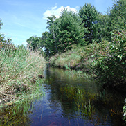
Surface water quality conditions in the Barbers Creek catchment are monitored by the Rideau Valley Conservation Authority’s (RVCA) Baseline Water Quality Monitoring Program. The Baseline Water Quality Program focuses on streams; data is collected for 22 parameters including nutrients (total phosphorus, total Kjeldahl nitrogen and ammonia), E. coli, metals (like aluminum and copper) and additional chemical/physical parameters (such as alkalinity, chlorides, pH and total suspended solids). Figure 1 shows the location of the monitoring site in the catchment.

The water quality ratings for the Barbers Creek catchment is “Fair” (Table 1) as determined by the Canadian Council of Ministers of the Environment (CCME) Water Quality Index CCME and is largely influenced by high nutrient concentrations, metals and high bacterial counts. A "Fair" rating indicates that water quality is usually protected but is occasionally threatened or impaired; conditions sometimes depart from natural or desirable levels. Each parameter is evaluated against established guidelines to determine water quality conditions. Those parameters that frequently exceed guidelines are presented below. Analysis of the data has been broken into two periods; 2003 to 2008 and 2009 to 2014 for the stream monitoring site located on Barbers Creek (BAR-01) to examine if conditions have changed between these periods. Table 1 shows the overall rating for the monitored surface water quality site within the Barbers Creek catchment and Table 2 outlines the Water Quality Index (WQI) scores and their corresponding ratings.
| Sampling Site | Location | 2003-2008 | Rating |
|---|---|---|---|
| BAR-01 | Barbers Creek at County Rd. 16 | 68 | Fair |
| Sampling Site | Location | 2009-2014 | Rating |
| BAR-01 | Barbers Creek at County Rd. 16 | 71 | Fair |
| Rating | Index Score |
|---|---|
| Very Good (Excellent) | 95-100 |
| Good | 80-94 |
| Fair | 65-79 |
| Poor (Marginal) | 45-64 |
| Very Poor (Poor) | 0-44 |
Total phosphorus (TP) is used as a primary indicator of excessive nutrient loading and may contribute to abundant aquatic vegetation growth and depleted dissolved oxygen levels. The Provincial Water Quality Objective (PWQO) is used as the TP Guideline and states that in streams concentrations greater than 0.030 mg/l indicate an excessive amount of TP.
Total Kjeldahl nitrogen (TKN) and ammonia (NH3) are used as secondary indicators of nutrient loadings. RVCA uses a guideline of 0.500 mg/l to assess TKN[1] and the PWQO of 0.020 mg/l to assess NH3 concentrations in Barbers Creek.
Tables 3, 4 and 5 summarize average nutrient concentrations at monitored sites within the Barbers Creek catchment and show the proportion of results that meet the guidelines.
| Total Phosphorous 2003-2008 | |||
|---|---|---|---|
| Site | Average (mg/l) | Below Guideline | No. Samples |
| BAR-01 | 0.064 | 43% | 46 |
| Total Phosphorous 2009-2014 | |||
| Site | Average (mg/l) | Below Guideline | No. Samples |
| BAR-01 | 0.052 | 49% | 37 |
| Total Kjeldahl Nitrogen 2003-2008 | |||
|---|---|---|---|
| Site | Average (mg/l) | Below Guideline | No. Samples |
| BAR-01 | 1.011 | 4% | 46 |
| Total Kjeldahl Nitrogen 2009-2014 | |||
| Site | Average (mg/l) | Below Guideline | No. Samples |
| BAR-01 | 1.127 | 0% | 37 |
| Ammonia 2003-2008 | |||
|---|---|---|---|
| Site | Average (mg/l) | Below Guideline | No. Samples |
| BAR-01 | 0.068 | 38% | 16 |
| Ammonia 2009-2014 | |||
| Site | Average (mg/l) | Below Guideline | No. Samples |
| BAR-01 | 0.018 | 33% | 12 |
Elevated TP results were a regular occurrence at site BAR-01; 43 percent of samples were below the guideline in the 2003-2008 period (Figure 2); this increased to 49 percent of samples in the 2009-2014 period (Figure 3). The average TP concentration also decreased slightly from 0.064 mg/l (2003- 2008) to 0.052 mg/l (2009-2014).


TKN data show that the majority of results exceeded the guideline (Figures 4 and 5); there were very few samples (4 percent) below the guideline in the 2003-2008 period and this declined to no samples below the guideline in the 2009-2014 period. The average concentration increased from 1.011 mg/l (2003-2008) to 1.127 mg/l (2003-2008) (Table 4).


NH3 data also reported regular instances of exceedances and results at this site were generally above the guideline of 0.020 mg/l (Figures 6 and 7); the proportion of samples below the guideline declined slightly from 38 percent to 33 percent. The average concentration in the 2003-2008 monitoring period was 0.068 mg/l, well above the PWQO. In the 2009-2014 period the average concentration declined to 0.018 mg/l which is still slightly above the PWQO (Table 5).


The data shows that nutrient enrichment is a characteristic of Barbers Creek. High nutrient concentrations can help stimulate the growth of algae blooms and other aquatic vegetation in a waterbody and deplete oxygen levels as the vegetation dies off.
E. coli is used as an indicator of bacterial pollution from human or animal waste; in elevated concentrations it can pose a risk to human health. The PWQO of 100 colony forming units/100 milliliters (CFU/100 ml) is used to assess E. coli. Counts greater than this guideline indicate that bacterial contamination may be a problem within the watercourse.
Table 6 summarizes the geometric mean[2] for the monitored site on Barbers Creek and shows the proportion of samples that meet the E. coli guideline of 100 CFU/100 ml. The results of the geometric mean with respect to the guideline for the two periods, 2003-2008 and 2009- 2014, are shown in Figures 8 and 9 respectively.
| E.coli 2003-2008 | |||
|---|---|---|---|
| Site | Geometric Mean (CFU/100ml) | Below Guideline | No. Samples |
| BAR-01 | 160 | 24% | 45 |
| E.coli 2009-2014 | |||
| Site | Geometric Mean (CFU/100ml) | Below Guideline | No. Samples |
| BAR-01 | 104 | 41% | 37 |
E. coli counts at site BAR-01 indicate an improvement with regard to bacterial contamination. The proportion of samples below the guideline increased from 24 percent (Figure 8) to 41 percent (Figure 9) and the count at the geometric mean decreased from 215 (2003-2008) to 193 (2009-2014) CFU/100ml.


This data shows that bacterial contamination is a concern on Barbers Creek. There has been an improvement from the 2003-2008 to the 2009-2014 monitoring period, however the count at the geometric mean is above the PWQO for both monitoring periods. Properly maintaining septic systems, enhancing shoreline buffers and restricting cattle access can help to improve E.coli levels in Barbers Creek.
Of the metals routinely monitored in Barbers Creek, aluminum (Al), iron (Fe) and copper (Cu) occasionally reported concentrations above their respective PWQOs. In elevated concentrations, these metals can have toxic effects on sensitive aquatic species.
Tables 7, 8 and 9 summarize metal concentrations at site BAR-01 and show the proportion of samples that meet guidelines. Figures 10 to 15 show metal concentrations with respect to the guidelines for the two periods of interest, 2003–2008 and 2009–2014. The guideline metal concentrations as described by the PWQO are 0.75mg/L Al, 0.300mg/L Fe and 0.005mg/L Cu.
| Aluminum 2003-2008 | |||
|---|---|---|---|
| Site | Average (mg/l) | Below Guideline | No. Samples |
| BAR-01 | 0.120 | 63% | 27 |
| Aluminum 2009-2014 | |||
| Site | Average (mg/l) | Below Guideline | No. Samples |
| BAR-01 | 0.031 | 84% | 25 |
Results from BAR-01 shows that Al concentrations had some exceedances with 63 percent of samples below the guideline in the 2003-2008 period (Figure 10). This improved to 84 percent of samples in the 2009-2014 period (Figure 11). The average concentration of Al was 0.120 mg/l from 2003-2008 which exceeds the guideline. From 2009-2014 the average concentration improved to 0.031 mg/l which is below the guideline.


| Iron 2003-2008 | |||
|---|---|---|---|
| Site | Average (mg/l) | Below Guideline | No. Samples |
| BAR-01 | 0.280 | 67% | 27 |
| Iron 2009-2014 | |||
| Site | Average (mg/l) | Below Guideline | No. Samples |
| BAR-01 | 0.083 | 96% | 25 |
Concentrations of Fe also exceeded the PWQO guideline at times but were generally lower than Al. The proportion of Fe samples below the guideline increased from 67 percent to 96 percent (Figures 12 and 13). Although there were observed exceedances, the average concentration of Fe did not exceed the guideline in both monitoring periods; 0.280 mg/l in 2003-2008 and .083 mg/l in 2009-2014.

 Figure 13 Iron concentrations in Barbers Creek, 2009-2014
| Copper 2003-2008 | |||
|---|---|---|---|
| Site | Average (mg/l) | Below Guideline | No. Samples |
| BAR-01 | 0.002 | 93% | 27 |
| Copper 2009-2014 | |||
| Site | Average (mg/l) | Below Guideline | No. Samples |
| BAR-01 | 0.009 | 88% | 25 |
Copper concentrations have occasionally exceeded the guidelines. In the 2003-2008 period 93 percent of samples were below the guideline (Figure 14) and declined to 88 percent of samples in the 2009–2014 period (Figure 15). This contributed to an increase in the average concentration from 0.002 mg/l (2003–2008) to 0.009 mg/l (2009–2014).


Aluminum and Iron concentrations declined, while Copper concentrations increased slightly between the two periods of interest. Efforts should continue to be made to identify pollution sources and implement best management practices to reduce any inputs such as runoff, metal alloys, fungicides and pesticides to improve overall stream health and lessen downstream impacts.
[1] No Ontario guideline for TKN is presently available; however, waters not influenced by excessive organic inputs typically range from 0.100 to 0.500 mg/l, Environment Canada (1979) Water Quality Sourcebook, A Guide to Water Quality Parameters, Inland Waters Directorate, Water Quality Branch, Ottawa, Canada
[2] A type of mean or average, which indicates the central tendency or typical value of a set of numbers by using the product of their values (as opposed to the arithmetic mean which uses their sum). It is often used to summarize a variable that varies over several orders of magnitude, such as E. coli counts.
![]()
The RVCA is part of the provincial Watershed Checkup Program.