1. Catchment Facts
General Geography
- The Rideau River flows through the heart of the Middle Rideau and is a focal point for residents and visitors to the area. It extends from the outlet of Lower Rideau Lake at Poonamalie (where there is one dam and one lock) to Burritts Rapids (where there is also a dam and lock), at which point it enters the Lower Rideau on its way to Rideau Falls. The Rideau River is also an integral part of the Rideau Canal National Historic Site of Canada and is a significant tourist attraction which draws boaters, cottagers, and campers to the area
- Smiths Falls, Merrickville and Burritts Rapids are the main settlements in the Middle Rideau subwatershed. Elsewhere, the Black Creek catchment is rural with agricultural land use and wetland
- Parks Canada staff manage water levels for recreational purposes along the Rideau Canal/Waterway that flows by the catchment, ensuring 1.5 metres of draft during the navigation season. In this managed system, water levels on the Rideau Canal are manipulated by operation of numerous dams. In the Middle Rideau subwatershed, Parks Canada staff operate 9 dam and lock complexes with 13 locks for a fall of 36.2 metres over 35.6 kilometres. Water levels are maintained as close as possible to set objectives through the May to October navigation season. The levels are lowered through the rest of October and into November and held at the winter levels until the spring freshet in late March or early April naturally increases inflows to the system. To reduce the impact of the higher flows in the spring, the amount of snow water equivalent, forecast rain, ice cover, flows and levels are assessed and the dams in the Middle Rideau reach are operated accordingly to quickly pass as much water as possible. In late April and early May, the dams are gradually closed and water levels are brought up to be ready, once again, for the navigation season.
Physical Geography
- All of the Black Creek catchment and the rest of the Middle Rideau subwatershed primarily resides within the Smith Falls Limestone Plain, which in this area, happens to consist of older Paleozoic quartz sandstone and dolostone of the March Formation. A small section of the Nepean sandstone, however, is also found along the northern boundary of the catchment. The bedrock in the southern part of the catchment is mainly overlain by a thin veneer of glacial sediment, referred to as ‘drift’ that is generally less than a metre in thickness;, although the landscape is also dotted with organic soils and some glacial till. The bedrock across the northern half of the catchment is mainly overlain by sandy glacial till and organic deposits associated with wetlands. Drumlins are found near the south eastern boundary of the catchment and a geologic fault likely transects the north western corner of the catchment
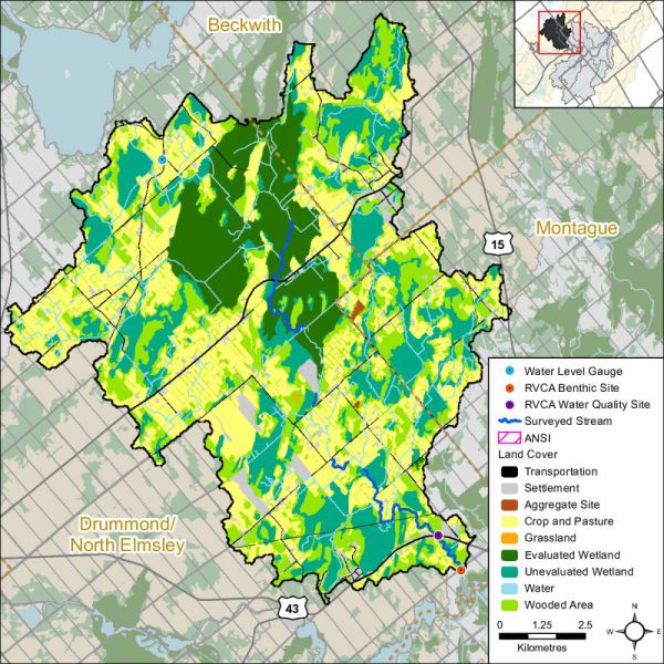
- Seventy-five percent of the catchment lies within the Township of Drummond/North Elmsley, 13 percent is in Beckwith Township and 12 percent is in the Township of Montague
- Black Creek catchment drainage area is 131 square kilometres and occupies about sixteen percent of the Middle Rideau subwatershed and three percent of the Rideau Valley watershed
Vulnerable Areas
- Lower reach of Black Creek is subject to a flooding hazard during the regional storm flood (the 100 year flood). Surveys and studies undertaken in accordance with provincial standards have determined that the 100 year flood elevation in this area ranges from 122.97 metres above mean sea level at the upper, mapped extent of the regulation limit at Poonamalie Side Road to 122.81 metres above mean sea level at its outlet to the Rideau River
- The Assessment Report developed under the Ontario Clean Water Act identifies the upper bedrock aquifer underlying all of the catchment area as a Highly Vulnerable Aquifer, although, where sediments are thicker in a local area, the vulnerability would be less. It also identifies the area of Nepean Sandstone found at the surface as a Significant Groundwater Recharge area along with a small part of the Village of Merrickville municipal Wellhead Protection Area being located in this catchment. Within a much more narrowly defined area along Poonamalie Road and Carroll Road is an area designated as an Intake Protection Zone to the Smiths Falls water supply and may be subject to Mississippi-Rideau Source Water Protection Zone policies
Development/Trends
- The catchment is dominated by the Township of Drummond/North Elmsley (D/NE). Those inland areas away from the Rideau River include mostly farms (livestock and pasturing) with less cropping than in other parts of the Township. Farming areas interspersed with large Provincially Significant Wetlands and other wooded areas. It should be noted that several hundred acres in the subwatershed has recently been developed with a total of four solar farms. Residential development is very scattered with single family residences and no major subdivisions. There are commercial and industrial uses along County Road 43, including the GIM salvage yard; however, in the larger catchment, other non- residential and non-agricultural uses are small and typically oriented locally and to the farming sector and no significant active recreational or tourism oriented area exists
- The main watercourse through the catchment is Black Creek. As it rarely exceeds 20 feet in width (and has been known to be essentially dry in extremely dry years), it is not a focus of development the way a larger waterbody would be. Impacts of farming on the watercourse are much the same as they are in any other setting
- Residential development in D/NE is generally very scattered with single family residences and no major subdivisions. Along County Road 43 to the west of Smiths Falls, there are some commercial and industrial uses (including GIM salvage yard) and a greater concentration of single family residences. Elsewhere, other non-residential and non-agricultural uses are small and typically oriented locally to the farming sector. No significant, active recreational or tourism oriented areas exist, other than the un-operational Donnybrooke site
- In recent years there has been limited development pressure in the general area (other than the four solar farms), with few severances and no subdivisions. There is a modest amount of development and more often redevelopment of commercial and industrial uses along Highway 43. It is unknown whether there will be a change in development pressure in coming years. For the most part, development in D/NE tends to follow along the Highway 7 corridor and closer to Perth, however if Smiths Falls were to grow there would likely be a spill-over. This area does not have easy or quick access to Ottawa
- Within the Beckwith Township and the Township of Montague areas of the catchment, development is comprised mainly of scattered single family residences along with farms. Gillies Corners is the main settlement in this area of the catchment, located along the Perth Road at its northeastern edge
Conditions at a Glance
Water Quality
- Surface chemistry water quality rating in Black Creek is “Fair” over two reporting periods (2003-2008 and 2009-2014). Elevated bacterial counts and nutrient concentrations from inflows of nutrients (from private septic systems, agricultural and residential surface water runoff) are a feature of Black Creek. Decreased nutrient and bacterial counts are needed to improve the overall health of the creek
- Instream biological water quality conditions at the Black Creek sample location range from “Poor” to “Fair” from 2003 to 2014 (using a grading scheme developed by Ontario Conservation Authorities in Ontario for benthic invertebrates) with an overall benthic invertebrate water quality rating of “Poor” determined for this period
Instream and Riparian
- Overall instream and riparian condition for the Black creek catchment as assessed by the stream characterization and headwater drainage feature assessment programs show that Black Creek and its tributaries are in generally good condition. The majority of the system has low erosion levels, a healthy riparian corridor with good instream diversity of aquatic habitat. The headwater areas in the upper catchment are dominated by wetland habitat and as you move downstream the creek is classified as a municipal drain. There are opportunities along some of the drainage features and smaller tributaries to enhance riparian habitat conditions
- The Black Creek catchment has 26 species of recreational and bait fish and is classified as having a warm/cool water thermal guild that supports the Black Creek/Rideau River fishery
- In the Black Creek catchment, the riparian buffer (30 m. wide strip along the shoreline of all lakes and streams) is comprised of wetland (55 percent), crop and pastureland (28 percent), woodland (12 percent), roads (three percent) and settlement areas (two percent)
Land Cover
- Dominant land cover is crop and pastureland (35 percent) and wetland (35 percent) followed by woodland (23 percent), settlement areas (five percent) and roads (two percent). From 2008 to 2014, there was an overall change of 190 hectares (from one land cover class to another). Within the Black Creek catchment, change is primarily associated with crop and pastureland being converted to settlement (solar farms) and woodland to settlement (solar farms)
- Woodland cover in the catchment has decreased by two hectares between 2008 and 2014 and interior forest habitat has increased by 30 hectares
- Wetland cover has decreased by 16 percent (2181 ha) from pre-settlement times to the present and now occupies 36 percent of the catchment area
Other
- There are approximately 675 in-use water wells with provincial records in this catchment. While most water wells are used for domestic water supply, in this catchment, many are used for agricultural purposes and several are used as commercial, public and municipal water supplies or monitoring wells
- There are no active Permits to Take Water, nor are there any open or closed bedrock quarries in the catchment. There are five sand and gravel pit licenses in the catchment but no primary sand and gravel aggregate resource
- An Environmental Compliance Approval has been issued for a renewable energy system in the vicinity of Armstrong and Glenview Roads
Catchment Care
- Thirty-seven stewardship projects have been completed with assistance from the RVCA’s Rural Clean Water and Tree Planting Programs (see Section 5 of this report for details)
- Black Creek surface chemistry water quality has been monitored by the RVCA through its Baseline Monitoring Program since 2003. The surface chemistry water quality at site COC-02 is monitored once a month from April to November
- RVCA has been collecting benthic invertebrates in Black Creek at the Poonamalie Road site since 2003
- RVCA conducted a fish survey along Black Creek in 2014
- RVCA completed a stream characterization survey on Black Creek in 2014, working upstream to the headwaters from the mouth of the creek where it empties into the Rideau River taking measurements and recording observations on instream habitat, bank stability, other attributes and preparing a temperature profile
- RVCA completed 30 headwater drainage feature assessments at road crossings in the Black Creek catchment in 2014. This protocol measures zero and first order headwater drainage features and is a rapid assessment method characterizing the amount of water, sediment transport, and storage capacity within headwater drainage features
- A watershed model developed by the RVCA in 2009 was used to study the hydrologic function of wetlands in the Rideau Valley Watershed, including those found in the Black Creek catchment
- The Townships of Beckwith, Drummond/North Elmsley and Montague have land use planning policies and zoning provisions - on water setbacks, frontage and naturalized shorelines and wetland protection - and in some instances use site plan control to implement these policies and provisions. Together with RVCA, the Townships work with landowners on a case by case basis to enable new development while ensuring the scale is suitable on the lot, impacts on neighbours are minimized and development maximizes the watercourse setback
- Development in and adjacent to the Provincially Significant Wetlands in the catchment (Black Creek, Port Elmsley No.2) are subject to Ontario Regulation 174-06 (entitled “Development, Interference with Wetlands and Alterations to Shorelines and Watercourses”) that protects the hydrologic function of the wetland and also protects landowners and their property from natural hazards (flooding, fluctuating water table, unstable soils) associated with them